Laceby
| Laceby | |
|---|---|
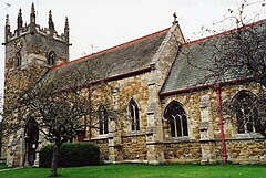
 St Margaret's Church |
|
| Laceby shown within Lincolnshire | |
| Population | 3,259 (2011) |
| OS grid reference | TA279087 |
| • London | 145 mi (233 km) S |
| Unitary authority | |
| Ceremonial county | |
| Region | |
| Country | England |
| Sovereign state | United Kingdom |
| Post town | GRIMSBY |
| Postcode district | DN37 |
| Dialling code | 01472 |
| Police | Humberside |
| Fire | Humberside |
| Ambulance | East Midlands |
| EU Parliament | Yorkshire and the Humber |
| UK Parliament | |
Laceby is a village and civil parish in North East Lincolnshire, England. It is situated on the A46 road, just outside the western boundary of Grimsby. Laceby's population at the 2001 Census was 2,886, increasing to 3,259 at the 2011 Census. The village is noted for its parish church, parts of which date to the 12th century.
A Mesolithic flint working site, to the north-east of the village, found in 1958, included examples of Neolithic leaf shaped arrowheads." While a 'findspot of possible Anglo-Saxon pottery' was discovered in Coopers Lane in 1969. Nearby Welbeck Hill is the site of Roman pottery finds, and an Anglo-Saxon cemetery.
According to A Dictionary of British Place Names, Laceby could derive from "a farmstead or village of a man called Leifr", 'Leifr' being an Old Scandinavian person name, and 'by', a farmstead, village or settlement.
Laceby is listed in the 1086 Domesday account as "Lenesbi" or "Levesbi", in the Bradley Hundred of the North Riding of Lindsey. The village contained 33 households, 4 villagers, 5 smallholders, 85 freemen and 3 priests. It comprised 16 ploughlands, a meadow of 360 acres (1.5 km2), woodland of 100 acres (0.4 km2), and 2 mills. The three Lords in 1066 were Erik, Tosti and Swein. In 1086 the land was passed to Bishop Odo of Bayeux, as Lord of the Manor and Tenant-in-chief.
...
Wikipedia

