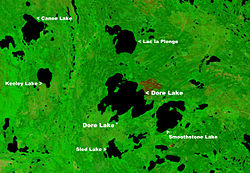
Lac la Plonge
| Lac la Plonge | |
|---|---|

|
|
| Location | Saskatchewan |
| Coordinates | 55°08′N 107°20′W / 55.133°N 107.333°WCoordinates: 55°08′N 107°20′W / 55.133°N 107.333°W |
| Primary outflows | La Plonge River |
| Basin countries | Canada |
| Settlements | Lac La Plonge |
Lac la Plonge is a glacial lake in Saskatchewan in the basin of the Beaver River near Lac Île-à-la-Crosse. It is located in the Boreal Forest near the Canadian Shield. Lac La Plonge on its north shore is accessed via Highway 165. The La Plonge River flows west from the north west section of the lake into the Beaver River at Beauval.
The lake's fish species include walleye, sauger, yellow perch, northern pike, lake trout, lake whitefish, cisco, white sucker, longnose sucker and burbot.
...
Wikipedia
