La Playa (de Ponce)
| Barrio Playa | |
|---|---|

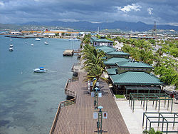
La Guancha Boardwalk, one of the landmarks in Barrio Playa
|
|
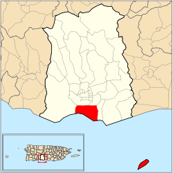
 Location of barrio Playa within the municipality of Ponce shown in red |
|
| Country |
|
| Territory |
|
| Municipality |
|
| Area | |
| • Total | 14.98 sq mi (38.8 km2) |
| • Land | 4.38 sq mi (11.3 km2) |
| • Water | 10.60 sq mi (27.5 km2) |
| Population (2000) | |
| • Total | 16,926 |
| • Density | 3,864/sq mi (1,492/km2) |
| Source: 2000 Census | |
Barrio Playa, also known as Playa de Ponce, Ponce Playa, or La Playa, is one of the thirty-one barrios that comprise the municipality of Ponce, Puerto Rico. Along with Bucaná, Canas, Vayas, and Capitanejo, Playa is one of the municipality's five coastal barrios. Barrio Playa also incorporates several islands, the largest of which is Caja de Muertos. It was founded in 1831.
Playa is an urban barrio located in the southern region of the municipality, within the limits of the city of Ponce, south of the traditional center of the city at Plaza Las Delicias, and on the shores of the Caribbean Sea. It is located at 17.9839°N 66.6128°W, and it has an elevation of 10 feet. The toponomy, or origin of the name, describes the geographic area the barrio occupies in southern Ponce and facing the Caribbean Sea.
It is bounded on the North by PR-2, on the South by the Caribbean Sea, on the West by Río Matilde, and on the East by Río Bucaná.
In terms of barrio-to-barrio boundaries, Playa is bounded in the North by Canas Urbano and San Anton, in the South by the Caribbean Sea, in the West by Canas, and in the East by Bucaná.
Unlike most other barrios of Ponce, Playa's landscape is entirely flat. Playa also has the second longest coastline of all five of Ponce's coastal barrios, after Canas. Playa has 4.6 square miles (12 km2) of land area and no water area.
...
Wikipedia
