La Paz, Tarlac
| La Paz | ||
|---|---|---|
| Municipality | ||

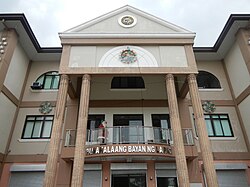
Town hall of La Paz
|
||
|
||
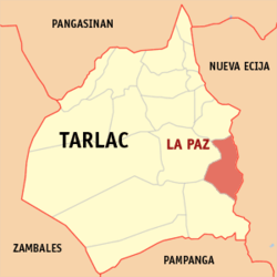
 Map of Tarlac showing the location of La Paz |
||
| Location within the Philippines | ||
| Coordinates: 15°26′35″N 120°43′44″E / 15.4431°N 120.7289°ECoordinates: 15°26′35″N 120°43′44″E / 15.4431°N 120.7289°E | ||
| Country | Philippines | |
| Region | Central Luzon (Region III) | |
| Province | Tarlac | |
| District | 3rd District | |
| Founded | January 24, 1892 | |
| Barangays | 21 | |
| Government | ||
| • Mayor | Michael M. Manuel | |
| Area | ||
| • Total | 114.33 km2 (44.14 sq mi) | |
| Population (2015 census) | ||
| • Total | 64,017 | |
| • Density | 560/km2 (1,500/sq mi) | |
| Time zone | PST (UTC+8) | |
| ZIP code | 2314 | |
| IDD : area code | +63 (0)45 | |
| Income class | 2nd class | |
La Paz is a 2nd class municipality in the province of Tarlac, Philippines. According to the 2015 census, it has a population of 64,017 people.
La Paz lies in the southeast portion of the province of Tarlac, 141 kilometres (88 mi) from Metro Manila, 17 kilometres (11 mi) from the provincial capital (Tarlac City) and 75 kilometres (47 mi) from the regional center (San Fernando City). It is bounded on the north by the town of Victoria, on the east by the Province of Nueva Ecija, on the south by the town of Concepcion and on the west by Tarlac City.
The municipality has a total land area of 11,433 hectares (28,250 acres), which represents 2.34% of the entire provincial area. La Paz is politically subdivided into 18 barangays, of which barangays San Isidro and San Roque are considered as urban areas and the rest of the barangays are considered rural areas.
La Paz is politically subdivided into 21 barangays:
The early history of La Paz is unclear. Legends state that there was an old pueblo called "Cama Juan" situated along the bank of the Chico River, bordering the province of Tarlac and Nueva Ecija. When the Chico River overflowed during a storm, a great flood swept the entire pueblo during the night. The flood is said to have devastated the area, claiming many lives.
This forced the inhabitants of "Cama Juan" to evacuate. The old site (Cama Juan) is known as "Balen Melakwan" or "Abandoned Town".
The inhabitants chose a field of evergreen grass and shrubbery on which to rebuild, which they named "Matayumtayum".
Towards the end of the nineteenth century, Francisco Macabulos and Captain Mariano Ignacio selected a more centrally located site for the future town to be known as La Paz. This existed only as a barrio of the town of Tarlac until 1892, when it was separated from the latter and rechristened in honor of its patron saint Nuestra Senora de La Paz y Buen Viaje. Its emergence as a new town gave its citizens a chance to run their own government with Martin Aquino as the first Governadorcillo.
...
Wikipedia


