Lötschberg Tunnel

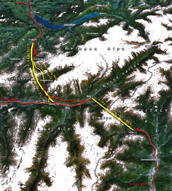
The Lötschberg Tunnel and its Base Tunnel together with the century-old Simplon Rail Tunnel form the western part of the Alptransit project
(yellow: major tunnels, red: existing main tracks, numbers: year of completion) |
|
| Overview | |
|---|---|
| Official name | German: Lötschberg Tunnel |
| Line | Lötschberg Line |
| Location | Traversing the Bernese Alps in Switzerland (Canton of Bern, canton of Valais) |
| Coordinates | 46°22′08″N 7°45′14″E / 46.369°N 7.754°E – 46°28′41″N 7°40′01″E / 46.478°N 7.667°E |
| System | BLS, SBB CFF FFS |
| Start | Kandersteg, canton of Bern, 1,200 m (3,900 ft) |
| End | Goppenstein, canton of Valais, 1,216 m (3,990 ft) |
| Operation | |
| Work begun | 7 March 1907 |
| Opened | 15 July 1913 |
| Owner | BLS NETZ AG |
| Operator | BLS |
| Traffic | Railway |
| Character | Passenger, Freight, Car Transport |
| Technical | |
| Length | 14.612 km (9.079 mi) |
| No. of tracks | One double-track |
| Track gauge | 1,435 mm (4 ft 8 1⁄2 in) (standard gauge) |
| Electrified | 15 kV 16.7 Hz |
| Highest elevation | 1,239.54 m (4,066.7 ft) |
| Lowest elevation | 1,200 m (3,900 ft) (north portal) |
| Grade | 3–7 ‰ |
The Lötschberg Tunnel is a 14.612 km (9.079 mi) long railway tunnel on the Lötschberg Line, which connects Spiez and Brig at the northern end of the Simplon Tunnel cutting through the Alps of Switzerland. Its ends are at the towns of Kandersteg in the canton of Berne and Goppenstein in the canton of Valais.
Construction began in 1907 and suffered delays by several severe accidents.
The tunnel is a single bore twin track.
The BLS AG company offers a car transport service through the tunnel, between Kandersteg station and Goppenstein station, for accompanied vehicles. The journey time of approximately 20 minutes, passengers remain in their cars in open sided car transport vehicles. At peak times, the car transport service operates in each direction every 7½ minutes.
The new Lötschberg Base Tunnel, opened on June 15, 2007, has been constructed some 400 m (1,312 ft) below the level of the current Lötschberg Tunnel as part of the NRLA (New Railway Link through the Alps) project.
Coordinates: 46°25′49″N 7°43′5″E / 46.43028°N 7.71806°E
...
Wikipedia
