Kyaikkami
|
Kyaikkami ကျိုက္ခမီမြို့ |
|
|---|---|
| Town | |
 |
|
| Location in Burma | |
| Coordinates: 16°04′48″N 97°34′03″E / 16.08000°N 97.56750°ECoordinates: 16°04′48″N 97°34′03″E / 16.08000°N 97.56750°E | |
| Country |
|
| Division | Mon State |
| Population (2005) | |
| • Religions | Buddhism |
| Time zone | MST (UTC+6.30) |
Kyaikkami (Burmese: ကျိုက္ခမီမြို့; MLCTS: kyuikhka.mi mrui.; pronounced [tɕaiʔkʰəmì mjo̰]; Mon: ကျာ်ခမဳ) is a resort town in the Mon State of south-east Myanmar.
During the time of the Ayutthaya Kingdom (an ancient kingdom in Thailand), the town was probably a vassal state of Ayutthaya and it was known in Thai as Chiang Kran (เชียงกราน) or Chiang Tran (เชียงตราน). It was renamed Amherst after William Amherst, 1st Earl Amherst, then governor-general of India who successfully seized the town during the First Anglo-Burmese War (1824–1826).
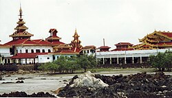
The town is situated on a peninsula about 48 km (30 mi) south of the town of Mawlamyine. It is a popular destination for local pilgrims and some tourists. The town has a pagoda (Kyaikkami Yele Pagoda or Kyaik-kami Ye Le Paya) just constructed on the sea using the natural foundation of its ocean reefs, which is connected with the corridor to the beach and always attracts the people for the festival of donations over the sea tides.
It got a record rainfall of 75 mm (2.95") on 14 Jan 2012. It was the highest amount of rainfall within 24 hours of January in the last 30 years.
It was originally a settlement of the Mon people, but modern Kyaikkami was founded by the British during the annexation of Tenasserim and Arakan states after the First Anglo-Burmese War. The town was a fishing village of the Mon but it used to be a certain headquarters for British commanding officers for their southern-Burma control. Because of this, many British officers and their Burmese wives and families lived in the area, with a large presence of Anglo-Burmese, as time progressed.
...
Wikipedia

