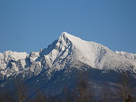
Kriváň (peak)
| Kriváň | |
|---|---|
 |
|
| Highest point | |
| Elevation | 2,495 m (8,186 ft) |
| Coordinates | 49°09′46″N 19°59′59″E / 49.16278°N 19.99972°ECoordinates: 49°09′46″N 19°59′59″E / 49.16278°N 19.99972°E |
| Naming | |
| Etymology | "angled" |
| Geography | |
| Location | Poprad/Liptovský Mikuláš, Prešov/Žilina, Slovakia |
| Parent range | High Tatras |
| Geology | |
| Mountain type | granite |
| Climbing | |
| First ascent | Andreas Jonas Czirbes, 1772 / 1773 |
| Easiest route | Hike from Štrbské Pleso |
Kriváň (![]() pronunciation ) is a mountain in the High Tatras, Slovakia, that dominates the upper part of the former Liptov County. Multiple surveys among nature lovers have ranked it as the country's most beautiful peak. Readily accessible along maintained marked trails and with the exceptional vistas afforded from its summit, it is the hikers' favorite mountain in the western part of the High Tatras. Kriváň has also been a major symbol in Slovak ethnic and national activism for the past two centuries. It has been referenced in works of art from 19th-century literature, through paintings, film documentaries, to a Polish rock track. A country-wide vote in 2005 selected it to be one of the images on Slovakia's euro coins.
pronunciation ) is a mountain in the High Tatras, Slovakia, that dominates the upper part of the former Liptov County. Multiple surveys among nature lovers have ranked it as the country's most beautiful peak. Readily accessible along maintained marked trails and with the exceptional vistas afforded from its summit, it is the hikers' favorite mountain in the western part of the High Tatras. Kriváň has also been a major symbol in Slovak ethnic and national activism for the past two centuries. It has been referenced in works of art from 19th-century literature, through paintings, film documentaries, to a Polish rock track. A country-wide vote in 2005 selected it to be one of the images on Slovakia's euro coins.
The name Kriváň, first recorded as Kriwan in 1639, is derived from the root kriv- meaning "bent" or "crooked". It reflects the angled appearance of its shape when viewed from the west and south, characterized in the work from 1639 as an "oxtail" (cauda bubula in the Latin original). The Slovak name is used in other languages including in Polish, rather than its potential Polonized version (Krzywań), except occasionally in Podhale in the immediate vicinity of the Tatras.
Two adjacent peaks in the nearby Malá Fatra range carry the same name, and so does the village of Kriváň farther away in southern Slovakia.
Based merely on visual observation, Kriváň competed for the status of the highest mountain in the High Tatras with Lomnický štít, which dominates the view from the east, until 1793 when the latter was accurately identified as the higher of the two (but wrongly as the highest peak in the mountain range, an error corrected by Ludwig Greiner in 1837):
...
Wikipedia

