Kröndlhorn
| Kröndlhorn | |
|---|---|

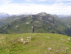
View of the Kröndlhorn and Kröndlberg massif from the Steinbergstein
|
|
| Highest point | |
| Elevation | 2,444 m (AA) (8,018 ft) |
| Isolation | 4.5 kilometres (2.8 mi) |
| Coordinates | 47°17′54″N 12°09′52″E / 47.298325°N 12.164439°ECoordinates: 47°17′54″N 12°09′52″E / 47.298325°N 12.164439°E |
| Geography | |
| Parent range | Kitzbühel Alps |
| Climbing | |
| Normal route | From the Windau valley via the Reinkarsee lake and the Kröndlberg |
The Kröndlhorn is a 2,444 m above sea level (AA) high mountain in the Kitzbühel Alps in Austria. It is one of the highest mountains on the main crest of the Kitzbühel Alps. The state border between Tyrol and Salzburger Land runs over its summit.
The Kröndlhorn rises north of the Salzach valley, southeast of the Kelchsau valley and southwest of the Windau valley. A secondary ridge to the main crest of the Kitzbühel Alps runs from the summit of the Kröndelhorn northwards in a curve. This ridge surrounds the cirque in which the mountain lake of the Reinkarsee has formed, at a height of 2,134 m. This cirque is the main source region of the Windauer Ache stream.
In front of the summit of the Kröndlhorn to the north is another peak, the Kröndlberg, only four metres lower, which looks like the actual summit when approaching from the north.
On the summit of the Kröndlhorn is a small chapel that only accommodates two people. It contains a stamp and a summit register. On the interior walls of the chapel obituary notices have been posted for many years.
In fine weather the summit offers a long view to the south into the Pinzgau region and the Reichenspitz Group and the High Tauern and the Krimml Waterfalls.
The chapel on the summit
The Kröndlhorn in autumn from the Windau valley ascent
Above the tree line the open slopes are used as grazing for sheep, goats, cows and horses. Herds of sheep, in particular, may be seen in summer around the Reinkarsee. A material ropeway runs from Holzlagerplatz to the Rotwand Grundalm. The trails are all signed with tree and ground markers.
...
Wikipedia

