Kostroma River
| Kostroma River | |
|---|---|

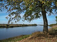
View of the Kostroma near the village of Most Sandogora
|
|

Volga basin
|
|
| Country | Russia |
| Basin features | |
| Main source | near Knyazhevo Chuhlomskogo |
| River mouth | Volga at Gorky Reservoir |
| Progression | Kostroma - Volga - Caspian Sea |
| River system | Volga |
| Basin size | 16,000 square kilometres (6,200 sq mi) |
| Tributaries | |
| Physical characteristics | |
| Length | 354 km (220 mi) |
| Discharge |
|
The Kostroma (Russian: Кострома́) is a river in the European part of Russia. It flows through the Kostroma and Yaroslavl Oblasts, and becomes a left tributary of the Volga, which it enters at the Gorky Reservoir, at the city of Kostroma, at 57°46′44″N 40°53′55″E / 57.77889°N 40.89861°E.
Prior to the flooding of the Gorky Reservoir in 1955-1957 the Kostroma River flowed into the Volga within the city limits of Kostroma. The Ipatiev Monastery stands at the old confluence of the Kostroma and the Volga.
The river is 354 kilometres (220 mi) long, and its drainage basin covers 16,000 square kilometres (6,200 sq mi). The average water flow is 71 cubic metres per second (2,500 cu ft/s) at the town of Buy, 124 kilometres (77 mi) from the mouth, and 85 cubic metres per second (3,000 cu ft/s) at the mouth.
Major tributaries include the Vocha, Mezenda, Wex, Tebza, and Sacha on the left, and the Shugoma, Svetlitsa, Lums, Selma, Monza, and Obnora on the right. Before the establishment of the Gorky Reservoir, the Sot and Mesa were also tributaries; they now flow directly into the reservoir.
...
Wikipedia
