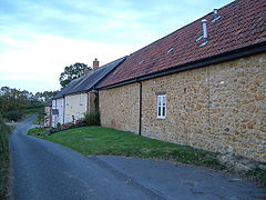
Knowle St Giles
| Knowle St Giles | |
|---|---|
 Malherbie Court, Knowle St Giles |
|
| Knowle St Giles shown within Somerset | |
| Population | 244 (2011) |
| OS grid reference | ST345115 |
| Civil parish | |
| District | |
| Shire county | |
| Region | |
| Country | England |
| Sovereign state | United Kingdom |
| Post town | CHARD |
| Postcode district | TA20 |
| Dialling code | 01460 |
| Police | Avon and Somerset |
| Fire | Devon and Somerset |
| Ambulance | South Western |
| EU Parliament | South West England |
| UK Parliament | |
Knowle St Giles is a village and civil parish in the South Somerset district of Somerset, England, situated on the River Isle 2 miles (3 km) south of Ilminster and 2.5 miles (4 km) north east of Chard. The village has a population of 244.
The parish includes the village of Cricket Malherbie.
In the Domesday book of 1086, Knowle St Giles is recorded as having small holdings by five villani and four bordarii. In the medieval period this grew with the reclamation of forest on Windwhistle Hill.
The parish of St Giles Knowles was part of the South Petherton Hundred.
The parish council has responsibility for local issues, including evaluating local planning applications, initiating projects for the maintenance and repair of parish facilities, consulting with the district council on the maintenance and improvement of highways, drainage, footpaths and street cleaning, working with the police, district council and neighbourhood watch groups on crime, security and traffic, and assessing environmental and conservation matters such as trees and listed buildings.
The village falls within the Non-metropolitan district of South Somerset, which was formed on 1 April 1974 under the Local Government Act 1972, having previously been part of Chard Rural District. The district council is responsible for local planning and building control, local roads, council housing, environmental health, markets and fairs, refuse collection and recycling, cemeteries and crematoria, leisure services, parks, and tourism.
...
Wikipedia

