Kittatinny Ridge
| Kittatinny Mountain | |
|---|---|

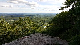
The Kittatinny Valley seen from Sunrise Mountain lookout
|
|
| Highest point | |
| Elevation | 1,803 feet (at High Point) |
| Coordinates | 41°08′10″N 74°47′49″W / 41.136°N 74.797°WCoordinates: 41°08′10″N 74°47′49″W / 41.136°N 74.797°W |
| Geography | |
| Location | New Jersey, United States |
| Parent range | Ridge-and-valley Appalachians |
Kittatinny Mountain (Lenape: Kitahtëne) is a long ridge traversing across northwestern New Jersey running in a northeast-southwest axis, a continuation across the Delaware Water Gap of Pennsylvania's Blue Mountain Ridge (also known as Kittatinny Ridge). It is the first major ridge in the far northeastern extension of the Ridge and Valley province of the Appalachian Mountains, and reaches its highest elevation (the state's highest), 1,803 feet, at High Point in Montague Township. Kittatinny Mountain forms the eastern side of Wallpack Valley; the western side comprises the Wallpack Ridge (highest elevation: 928 feet (283 m) above sea level.
Most of the range is publicly owned and protected. In the far northeast, High Point State Park protects the area around High Point itself. Further southwest, Stokes State Forest encompasses much of the range from the southern boundary of High Point State Park to the eastern boundary of the Delaware Water Gap National Recreation Area. The recreation area encompasses the entire southern half of the range, and also contains the smaller Worthington State Forest, which also protects the southwestern end of the range near the Delaware Water Gap itself.
The name comes from a Lenape Native American word meaning "endless hill" or "great mountain". The highest peak in the range is High Point at 1,803 feet (550 m), which is also the highest point in the state of New Jersey. This peak is located in High Point state park and has a road leading to the top. The second highest mountain is Sunrise Mountain, located within Stokes State Forest. The elevation here is 1,653 feet (504 m) and has a road leading almost to the top. At the top there is a shelter with a roof but no sides.
...
Wikipedia
