Kinzua Bridge State Park
| Kinzua Bridge State Park | |
| Pennsylvania State Park | |
|
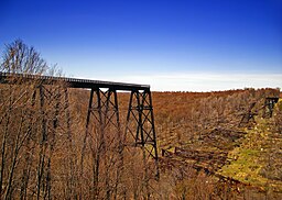
A view of the collapsed Kinzua Bridge taken May 2007.
|
|
| Named for: Kinzua Bridge | |
| Country | United States |
|---|---|
| State | Pennsylvania |
| County | McKean |
| Townships | Hamlin, Keating |
| Location | |
| - elevation | 2,136 ft (651.1 m) |
| - coordinates | 41°45′19″N 78°35′01″W / 41.75528°N 78.58361°WCoordinates: 41°45′19″N 78°35′01″W / 41.75528°N 78.58361°W |
| Area | 329 acres (133 ha) |
| Founded | 1963 |
| Management | Pennsylvania Department of Conservation and Natural Resources |
| IUCN category | III - Natural Monument |
| Website: Kinzua Bridge State Park | |
Kinzua Bridge State Park is a 329-acre (133 ha) Pennsylvania state park near Mount Jewett, in Hamlin and Keating Townships, McKean County, Pennsylvania in the United States. The park lies between U.S. Route 6 and Pennsylvania Route 59, along State Route 3011 just east of the Allegheny National Forest.
Kinzua Bridge State Park was chosen by the Pennsylvania Department of Conservation and Natural Resources (DCNR) and its Bureau of Parks as one of "25 Must-See Pennsylvania State Parks".
The park is noted as the site of the Kinzua Bridge spanning Kinzua Creek, original bridge built in 1882, subsequent bridge built in 1900 and destroyed in 2003 by a tornado. At the time it was built, the original (c. 1882) Kinzua Bridge was the highest, at 301 feet (92 m), and longest, at 2,053 feet (626 m), railway bridge in the world, given the distinction of being listed as a Historic Civil Engineering Landmark (the listing was in 1977). The Erie Railroad company originally owned and operated the bridge.
William Scranton, then governor of Pennsylvania, signed legislation creating Kinzua Bridge State Park in 1963, although the park did not officially open until 1970. In 1987, excursion trains of the Knox and Kane Railroad again began running on the bridge. The trains traveled from Kane with a trip through the Allegheny National Forest and made a stop on the bridge before returning to Kane.
...
Wikipedia


