Kingdom of Surrey
| Surrey | |||||
|---|---|---|---|---|---|
| County | |||||
|
|||||
 Surrey in England |
|||||
| Coordinates: 51°15′N 0°25′W / 51.250°N 0.417°WCoordinates: 51°15′N 0°25′W / 51.250°N 0.417°W | |||||
| Sovereign state |
|
||||
| Country |
|
||||
| Region | South East | ||||
| Established | Ancient | ||||
| Ceremonial county | |||||
| Lord Lieutenant | Michael More-Molyneux | ||||
| High Sheriff | Robert Stewart Napier (2017-18) | ||||
| Area | 1,663 km2 (642 sq mi) | ||||
| • Ranked | 35th of 48 | ||||
| Population (mid-2016 est.) | 1,176,500 | ||||
| • Ranked | 13th of 48 | ||||
| Density | 707/km2 (1,830/sq mi) | ||||
| Ethnicity | 95.0%White 2.2% S. Asian |
||||
| Non-metropolitan county | |||||
| County council | Surrey County Council | ||||
| Executive | Conservative | ||||
| Admin HQ | Kingston upon Thames (Extra-territorially) | ||||
| Area | 1,663 km2 (642 sq mi) | ||||
| • Ranked | 25th of 27 | ||||
| Population | 1,176,500 | ||||
| • Ranked | 6th of 27 | ||||
| Density | 707/km2 (1,830/sq mi) | ||||
| ISO 3166-2 | GB-SRY | ||||
| ONS code | 43 | ||||
| GSS code | E10000030 | ||||
| NUTS | UKJ23 | ||||
| Website | www |
||||
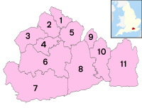
 Districts of Surrey Unitary County council area |
|||||
| Districts | |||||
| Members of Parliament | List of MPs | ||||
| Police | Surrey Police | ||||
| Time zone | Greenwich Mean Time (UTC) | ||||
| • Summer (DST) | British Summer Time (UTC+1) | ||||
| Surrey | |
|---|---|
| Population | |
| • 1891 | 452,218 |
| • 1971 | 1,002,832 |
| History | |
| • Created | c.825 |
| • Abolished | N/A |
| • Succeeded by | N/A |
| Status | Administrative county |
| • HQ |
Newington 1889–1893 Kingston upon Thames from 1893 |
 |
|
Surrey /ˈsʌri/ is a county in the south east of England. It shares borders with Kent to the east, East Sussex to the south-east, West Sussex to the south, Hampshire to the west and south-west, and Berkshire to the north-west and Greater London to the north-east. The county town is Guildford.Surrey County Council sits outside its jurisdiction in Kingston upon Thames, a town which has been administered as part of Greater London since 1965. With a resident population of 1.1 million, Surrey is the most densely populated and third-most-populous county in the South East region.
Today, administrative Surrey is divided into eleven districts: Elmbridge, Epsom and Ewell, Guildford, Mole Valley, Reigate and Banstead, Runnymede, Spelthorne, Surrey Heath, Tandridge, Waverley, and Woking. Services such as roads, mineral extraction licensing, education, strategic waste and recycling infrastructure, birth, marriage, and death registration, and social and children's services are administered by Surrey County Council. The London boroughs of Lambeth, Southwark, Wandsworth, and parts of Lewisham and Bromley were in Surrey until 1889. The boroughs of Croydon, Kingston upon Thames, Merton, Sutton and Richmond upon Thames south of the River Thames were part of Surrey until 1965, when they too were absorbed into Greater London. In the same year, the county was extended north of the Thames by the addition of Spelthorne, as a result of the dissolution of Middlesex. Due to this expansion, modern Surrey also borders on the London boroughs of Hillingdon, Hounslow, Kingston upon Thames, Sutton, Croydon and Bromley. Surrey is noted for being a particularly wealthy county due in large part to its proximity to London and to Heathrow and Gatwick airports along with access to major arterial road routes (including the M25, M3 and M23) and frequent rail services into Central London. It has the highest GDP per capita of any English county and some of the highest property values outside Inner London.
...
Wikipedia


