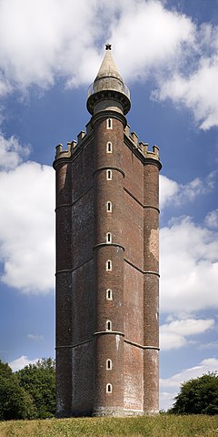
King Alfred's Tower
| King Alfred's Tower | |
|---|---|
 |
|
|
Location within Somerset
|
|
| General information | |
| Town or city | Brewham, Somerset |
| Country | England |
| Coordinates | 51°06′54″N 2°21′54″W / 51.115°N 2.365°W |
| Construction started | 1769 |
| Completed | 1772 |
| Client | Henry Hoare |
| Height | 49 metres (161 ft) |
| Design and construction | |
| Architect | Henry Flitcroft |
King Alfred's Tower, also known as The Folly of King Alfred the Great or Stourton Tower, is a folly tower. It is in the parish of Brewham in the English county of Somerset, and was built as part of the Stourhead estate and landscape. The tower stands on Kingsettle Hill and belongs to the National Trust. It is designated as a grade I listed building.
Henry Hoare II planned in the 1760s the tower to commemorate the end of the Seven Years' War against France and the accession of King George III near the location of 'Egbert's stone' where it is believed that Alfred the Great, King of Wessex, rallied the Saxons in May 878 before the important Battle of Edington. It was damaged by a plane in 1944 and restored in the 1980s.
The 49-metre-high (161 ft) triangular tower has a hollow centre and is climbed by means of a spiral staircase in one of the corner projections. It includes a statue of King Alfred and dedication inscription.
The tower stands near the location of 'Egbert's stone', where it was said that Alfred the Great, King of Wessex, rallied the Saxons in May 878 before the important Battle of Edington (historically known as the battle of Ethandun ), where the Danish army, led by Guthrum the Old was defeated. It is the start of the Leland Trail, a 28-mile (45.1 km) footpath which runs from King Alfred's Tower to Ham Hill Country Park.
...
Wikipedia

