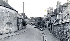
King's Cliffe
| Kings Cliffe | |
|---|---|
 The village in the early 1950s |
|
| Kings Cliffe shown within Northamptonshire | |
| Population | 1,202 (2011 Census) |
| OS grid reference | TL0097 |
| District | |
| Shire county | |
| Region | |
| Country | England |
| Sovereign state | United Kingdom |
| Post town | Peterborough |
| Postcode district | PE8 |
| Dialling code | 01780 |
| Police | Northamptonshire |
| Fire | Northamptonshire |
| Ambulance | East Midlands |
| EU Parliament | East Midlands |
| UK Parliament | |
| Website | King's Cliffe Parish Council |
Kings Cliffe (variously spelt King's Cliffe, King's Cliff, Kings Cliff, Kingscliffe) is a village and civil parish on Willow Brook, a tributary of the River Nene, about 9 miles (14 km) northeast of Corby in East Northamptonshire. The parish adjoins the county boundary with the City of Peterborough and the village is about 12 miles (19 km) west of the city centre. The village is not far from the boundary with Lincolnshire and about 6 miles (10 km) south of Stamford.
The 2001 Census recorded a parish population of 1,137 people, increasing to 1,202 at the 2011 Census.
The 1871 Census recorded a parish population of 1259. The 1891 Census recorded the parish population as having fallen to 1,082, occupying 262 "inhabited houses"
The Church of England parish church of All Saints has a central tower that is Norman, with late 13th century upper parts and broach spire. The nave has a Decorated Gothic west window and there are north and south aisles with 14th century arcades. The font is also 14th century. Later features are the Perpendicular Gothic clerestory, roof and remodelling of the north and south arches supporting the tower. Inside the church is a monument erected in 1623 to the Thorpe family, whose descendant John Thorpe (1565–1655) was a notable Elizabethan and Jacobean architect.
...
Wikipedia

