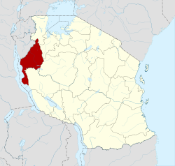
Kigoma Region
|
Kigoma Region Mkoa wa Kigoma (Swahili) |
|
|---|---|
| Region | |

Lake Tanganyika shore
|
|
 Location in Tanzania |
|
| Country | Tanzania |
| Zone | Central |
| Capital | Kigoma |
| Government | |
| • Regional Commissioner | Issa Machibya |
| Area | |
| • Total | 37,040 km2 (14,300 sq mi) |
| Population (2012) | |
| • Total | 2,127,930 |
| • Density | 57/km2 (150/sq mi) |
| Time zone | EAT (UTC+3) |
| Postcode | 47xxx |
| Area code(s) | 028 |
| Website | kigoma |
Kigoma Region is one of Tanzania's 30 administrative regions. The regional capital is the city of Kigoma. According to the 2012 national census, the region had a population of 2,127,930, which was higher than the pre-census projection of 1,971,332. For 2002-2012, the region's 2.4 percent average annual population growth rate was tied for the fourteenth highest in the country. It was also the sixteenth most densely populated region with 57 people per square kilometer. With a size of 45,066 square kilometres (17,400 sq mi), the region is slightly smaller than Estonia (45,227 square kilometres (17,462 sq mi)).
Kigoma Region resides in the northwestern corner of Tanzania, on the eastern shore of Lake Tanganyika. The region lies at about 5° south and 30° east of Greenwich. The region is bordered to the north by both Burundi and the Kagera Region. To the east, it is bordered by the Shinyanga and Tabora regions, to the south by the Rukwa Region, and to the west by Lake Tanganyika, which forms a border with the Democratic Republic of the Congo.
The region's total area is 45,066 square kilometres (17,400 sq mi), of which 37,037 square kilometres (14,300 sq mi) is land and 8,029 square kilometres (3,100 sq mi) is water. The region's total area is just 161 square kilometres (62 sq mi) less than that of Estonia. As of 1998[update], approximately 20,000 square kilometres was in forests and 12,000 square kilometres was suitable for grazing or farming.
Kigoma Region is on a plateau that slopes from the northeast at about 1,750 meters down to 800 meters at the shore of lake Tanganyika. The topography in the north and east is gently rolling hills that gradually become steeper as they get closer to the Albertine Rift margin. The most important river is the Malagarasi, with the Luiche and the Ruchugi being the two other major rivers draining the region.
...
Wikipedia
