Keystone Heights, Florida
| Keystone Heights, Florida | |
|---|---|
| City | |

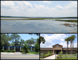
Images top, left to right: Lake Geneva, City Hall, Keystone Heights Junior/Senior High School
|
|
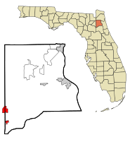
 Location in Clay County and the state of Florida |
|
| Coordinates: 29°47′14″N 82°1′59″W / 29.78722°N 82.03306°WCoordinates: 29°47′14″N 82°1′59″W / 29.78722°N 82.03306°W | |
| Country |
|
| State |
|
| County | Clay |
| Area | |
| • Total | 1.11 sq mi (2.88 km2) |
| • Land | 1.10 sq mi (2.85 km2) |
| • Water | 0.01 sq mi (0.03 km2) |
| Elevation | 141 ft (43 m) |
| Population (2014) | |
| • Total | 1,403 |
| • Density | 1,275/sq mi (492/km2) |
| Time zone | Eastern (EST) (UTC-5) |
| • Summer (DST) | EDT (UTC-4) |
| ZIP code | 32656 |
| Area code(s) | 352 |
| FIPS code | 12-36475 |
| GNIS feature ID | 0285088 |
Keystone Heights is a city located in southwestern Clay County, Florida, United States. The population of the city was 1,350 at the 2010 census.
The city was founded by Pennsylvanians who named it after their home state's nickname, the "Keystone State".
Residents began relocating here in the early 1920s, and the city was chartered in April 1925.
Keystone Heights is located in northeast Florida in the southwest corner of Clay County, at 29°47′14″N 82°1′59″W / 29.78722°N 82.03306°W (29.787243, -82.033026). The city overlooks the north shore of Lake Geneva. State Road 21 leads northeast 30 miles (48 km) (via SR 16 to Green Cove Springs, the Clay County seat, and south 18 miles (29 km) to Hawthorne. SR 100 crosses SR 21 and leads north 12 miles (19 km) to Starke and southeast 26 miles (42 km) to Palatka.
According to the United States Census Bureau, the city has a total area of 1.1 square miles (2.9 km2), of which 0.012 square miles (0.03 km2), or 1.16%, is water.
Some of the attractions that can be found in the historic town of Keystone include a weekly farmers' market, Keystone Beach (where alligators nest), a bike path that runs through the town center, Keystone Heights Fighting Indians football team, the Santa Fe College Watson Center, and the Donald Ross designed Lakeside Links Golf Club.
...
Wikipedia
