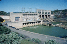
Keswick Dam
| Keswick Dam | |
|---|---|
 |
|
| Country | United States |
| Location | Shasta County, California |
| Coordinates | 40°36′43″N 122°26′45″W / 40.61194°N 122.44583°WCoordinates: 40°36′43″N 122°26′45″W / 40.61194°N 122.44583°W |
| Construction began | 1941 |
| Opening date | 1950 |
| Owner(s) | U.S. Bureau of Reclamation |
| Dam and spillways | |
| Type of dam | Concrete gravity |
| Impounds | Sacramento River |
| Height | 157 ft (48 m) |
| Length | 596 ft (182 m) |
| Dam volume | 214,000 cu yd (164,000 m3) |
| Spillways | Gated overflow |
| Spillway capacity | 250,000 cu ft/s (7,100 m3/s) |
| Reservoir | |
| Creates | Keswick Reservoir |
| Total capacity | 23,800 acre·ft (29,400,000 m3) |
| Catchment area | 6,380 sq mi (16,500 km2) |
| Normal elevation | 601.6 ft (183.4 m) |
| Power station | |
| Turbines | 3 |
| Installed capacity | 117 MW |
| Annual generation | 383 million KWh |
Keswick Dam is a concrete gravity dam on the Sacramento River about 2 miles (3.2 km) northwest of Redding, California. Part of the Bureau of Reclamation's Central Valley Project, the dam is 157 feet (48 m) high and impounds the Keswick Reservoir, which has a capacity of 23,800 acre·ft (29,400,000 m3). Its power plant has three turbines with a generating capacity of 117 megawatts (MW), uprated from the original 75 MW in 1992. The dam and reservoir serve as a forebay to regulate peaking power releases from the Shasta Dam upstream. The electrical substation at Keswick Dam distributes power from the Keswick power plant, the power plants at Trinity Dam and Lewiston Dam, the Judge Francis Carr Power plant near Whiskeytown Lake and the Spring Creek Power plant, which is located just northwest of Keswick Dam.
Keswick Dam was part of the Central Valley Project. This was started due to unequal water allocation, which left some landowners with no water supply, especially during the summer season, when water diversions for irrigation and domestic use were required in prolonged hot and dry weather. Water scarcity started in the 19th century in the gold-mining era. The discovery of gold mines in the 1840s attracted a flood of immigrants to California. After a few years, many immigrants moved into agriculture as it appeared to provide more stability than gold mining. Central Valley had fertile soils, abundant water, and a flat gentle topography suitable for farming. The California Legislature immediately enacted laws to deal with the state's water scarcity issue, and adopted riparian water rights. This law had limitations: the owners of land bordering water had a right to a reasonable amount of that water, but owners whose land did not border bodies of water had no rights to any of the water. Due to the usage restrictions arising from the riparian rights, the government directed state engineers to come up with a plan for the entire state that would accomplish a fair distribution of water for irrigation and domestic uses. An increase in demand for food caused a shift from small-scale farming to large-scale intensive farming. The low topography of the land caused flooding in the winter rainy season, but severe drought followed in summer months. Low water flow caused an increase in salinity, which resulted in the intrusion of salt in some parts of the valley, especially in the Bay. The Keswick project was primarily intended for irrigation purposes, but it became a multipurpose project for flood control, improvement in navigation of the Sacramento River, the supply of water to domestic and industrial users, the generation of electric power, the conservation of fish and wildlife, the creation of opportunities for recreation, and the enhancement of water quality.
...
Wikipedia
