Kendall, FL
| Kendall | |
|---|---|
| CDP & unincorporated community | |

Dadeland forms the de facto downtown area of Kendall
|
|
 Location in Miami-Dade County and the state of Florida |
|
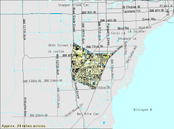
 U.S. Census Bureau map of Kendall CDP showing boundaries |
|
| Coordinates: 25°40′0″N 80°21′24″W / 25.66667°N 80.35667°WCoordinates: 25°40′0″N 80°21′24″W / 25.66667°N 80.35667°W | |
| Country | United States |
| State | Florida |
| County | Miami-Dade |
| Government | |
| • Governing body | Miami-Dade County |
| • Mayor | Carlos A. Giménez |
| Area | |
| • CDP & unincorporated community | 16.3 sq mi (42 km2) |
| • Land | 16.1 sq mi (42 km2) |
| • Water | 0.2 sq mi (0.5 km2) |
| • Metro | 6,137 sq mi (15,890 km2) |
| Elevation | 13 ft (4 m) |
| Population (2010) | |
| • CDP & unincorporated community | 75,371 |
| • Density | 4,600/sq mi (1,800/km2) |
| • Metro | 5,413,212 |
| • Metro density | 880/sq mi (340/km2) |
| Time zone | Eastern (EST) (UTC-5) |
| • Summer (DST) | EDT (UTC-4) |
| Area code(s) | 305, 786 |
| FIPS code | 12-36100 |
| GNIS feature ID | 0285050 |
Kendall is a census-designated place and unincorporated community in Miami-Dade County, Florida, United States. As of the 2010 census, the area had a total population of 75,371.
While the US Census Bureau has defined the boundaries of Kendall, many locals have their own definitions. Some believe the communities of West Kendall, Glenvar Heights, Sunset, Olympia Heights, Westwood Lakes and Tamiami to all be sub-communities of Kendall, while some people also believe the neighborhood of The Falls to be a separate entity.
Kendall is served by the Miami Metrorail at Dadeland North and Dadeland South stations in its northeastern end. Both stations provide metro service from Dadeland to nearby commercial centers like the City of Coral Gables, Downtown Miami, and Miami International Airport. Dadeland South station is a major transit depot in the area, connecting the southernmost cities of Homestead and Florida City to Metrorail via limited-stop bus rapid transit along the South Miami-Dade Busway.
...
Wikipedia
