Kenbridge, Virginia
| Kenbridge, Virginia | |
|---|---|
| Town | |

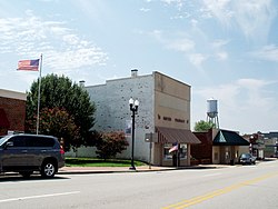
Central Kenbridge
|
|
 Location in Virginia |
|
| Coordinates: 36°57′46″N 78°7′37″W / 36.96278°N 78.12694°WCoordinates: 36°57′46″N 78°7′37″W / 36.96278°N 78.12694°W | |
| Country | United States |
| State | Virginia |
| County | Lunenburg |
| Founded | 1908 |
| Government | |
| • Mayor | Emory Hodges |
| Area | |
| • Total | 2.0 sq mi (5.3 km2) |
| • Land | 2.0 sq mi (5.3 km2) |
| • Water | 0.0 sq mi (0.0 km2) |
| Elevation | 515 ft (157 m) |
| Population (2000) | |
| • Total | 1,253 |
| • Density | 614.6/sq mi (237.3/km2) |
| Time zone | Eastern (EST) (UTC-5) |
| • Summer (DST) | EDT (UTC-4) |
| ZIP code | 23944 |
| Area code(s) | 434 |
| FIPS code | 51-41832 |
| GNIS feature ID | 1495781 |
Kenbridge is a town in Lunenburg County, Virginia, United States. The population was 1,253 at the 2000 census. It is in a tobacco farming area. The area is home to noted folk artist Eldridge Bagley.
Kenbridge is located at 36°57′46″N 78°7′37″W / 36.96278°N 78.12694°W (36.962805, -78.126896).
According to the United States Census Bureau, the town has a total area of 2.0 square miles (5.3 km²), all of it land.
Brickland, the Fifth Avenue Historic District, Flat Rock, and the Jones Farm are listed on the National Register of Historic Places.]].
As of the census of 2000, there were 1,253 people, 529 households, and 320 families residing in the town. The population density was 614.6 people per square mile (237.1/km²). There were 579 housing units at an average density of 284.0 per square mile (109.6/km²). The racial makeup of the town was 51.56% White, 44.93% African American, 0.40% Asian, 1.28% from other races, and 1.84% from two or more races. Hispanic or Latino of any race were 4.39% of the population.
...
Wikipedia
