Kemmental
| Kemmental | ||
|---|---|---|

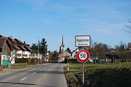
Hugelshofen
|
||
|
||
| Coordinates: 47°37′N 9°10′E / 47.617°N 9.167°ECoordinates: 47°37′N 9°10′E / 47.617°N 9.167°E | ||
| Country | Switzerland | |
| Canton | Thurgau | |
| District | Kreuzlingen | |
| Area | ||
| • Total | 25.02 km2 (9.66 sq mi) | |
| Elevation | 548 m (1,798 ft) | |
| Population (Dec 2015) | ||
| • Total | 2,393 | |
| • Density | 96/km2 (250/sq mi) | |
| Postal code | 8565, 8566, 8573 | |
| SFOS number | 4666 | |
| Localities | Alterswilen, Altishausen, Bommen, Dotnacht, Ellighausen, Engelswilen, Hugelshofen, Lipperwilen, Lippoldswilen, Neuwilen, Schwaderloh, Siegershausen | |
| Surrounded by | Berg, Kreuzlingen, Lengwil, Märstetten, Tägerwilen, Wäldi, Weinfelden, Wigoltingen | |
| Website |
www SFSO statistics |
|
Kemmental is a municipality in the district of Kreuzlingen in the canton of Thurgau in Switzerland.
The municipality was formed on 1 January 1996 through the merger of Alterswilen, Hugelshofen, Altishausen, Dotnacht, Ellighausen, Lippoldswilen, Neuwilen and Siegershausen.
Each of the former municipalities that now make up Kemmental had a long history as an independent municipality. Alterswilen is first mentioned in 1248 as Alterswilaer while the hamlet of Bommen was first mentioned in 1348 as Boumen. Altishausen is first mentioned in 1159 as Altinshusin. Ellighausen is first mentioned in 1331 as Adlikusen. Of the other villages that made up Ellighausen, Bächi was mentioned in 1259 as Baecho, Geboltschhusen in 1385 as Geboltzhusen. Ellighausen also included the hamlet of Neumühle. Lippoldswilen is first mentioned in 1303 as Lupoltwile. Neuwilen is first mentioned in 1159 as Nunewillare. Siegershausen is first mentioned in 1227 as Sigehardishusin. Hugelshofen is first mentioned in 1176 as Hugolteshouen. Dotnacht is first mentioned in 824 as Tottinheiche, and Altshof, a village in the former municipality of Dotnacht is first mentioned in 775 as Adalolteshoba.
Kemmental has an area, as of 2009[update], of 25.02 square kilometers (9.66 sq mi). Of this area, 17.01 km2 (6.57 sq mi) or 68.0% is used for agricultural purposes, while 5.78 km2 (2.23 sq mi) or 23.1% is forested. Of the rest of the land, 1.99 km2 (0.77 sq mi) or 8.0% is settled (buildings or roads), 0.11 km2 (27 acres) or 0.4% is either rivers or lakes and 0.16 km2 (0.062 sq mi) or 0.6% is unproductive land.
...
Wikipedia


