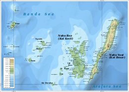
Kei Islands
| Native name: KaiKai | |
|---|---|

Kai islands
|
|
 |
|
| Geography | |
| Location | South-east Asia |
| Coordinates | 5°45′S 132°44′E / 5.75°S 132.73°E |
| Total islands | 47 |
| Major islands | Kai Besar, Kai Kecil |
| Area | 1,438 km2 (555 sq mi) |
| Highest elevation | 90 m (300 ft) |
| Highest point | 82 meters altitude |
| Administration | |
| Province | Maluku |
| Largest settlement | Alaku Malaki |
The Kai Islands (also Kei Islands) of Indonesia are a group of islands located in the southeastern part of the Maluku Islands in Maluku Province. The Malakus have been known as the Spice Islands due to region specific plants such as nutmeg, mace and cloves that originally intrigued European nations of the 16th century.
Though originally Melanesian, many islanders were exterminated in the 17th century during the spice wars, particularly in the Banda Islands. A second influx of Austronesian immigrants began in the early twentieth century under the Dutch and continued in the Indonesian era.
The islands consist of the Maluku Tenggara (Southeast Maluku) Regency within the Maluku Province. The Regency (which excludes the city of Tual) is sub-divided into six districts (kecamatan).
Inhabitants called the islands Nuhu Evav (Evav Islands) or Tanat Evav (Evav Land), but they were known as Kei to people from neighboring islands. The islands are located on the edge of the Banda Sea, south of the Bird's Head Peninsula of New Guinea, west of the Aru and Tayandu Islands, and northeast of the Tanimbar Islands.
The Kai islands are made up of numerous islands, including:
The Kai Islands' total land area is 1,438 km2 (555 sq mi).
Kai Besar is mountainous and densely forested. Its capital is the town of Tual. Kai is famous for the beauty of its beaches, notably in Pasir Panjang.
...
Wikipedia
