Kati
| Kati | |
|---|---|
| Commune and town | |

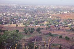
Kati seen from surrounding hills
|
|
| Location within Mali | |
| Coordinates: 12°44′48″N 8°4′17″W / 12.74667°N 8.07139°WCoordinates: 12°44′48″N 8°4′17″W / 12.74667°N 8.07139°W | |
| Country |
|
| Region | Koulikoro |
| Cercle | Kati Cercle |
| Urban Commune | Kati |
| Elevation | 481 m (1,578 ft) |
| Population (2009 census) | |
| • Total | 114,983 |
| Time zone | GMT (UTC+0) |
Kati is an urban commune and the largest town in Mali's Koulikoro Region. The town is situated 15 km northwest of Bamako, Mali's capital, on the Dakar-Niger Railway. In the 2009 census, the commune had a population of 114,983.
Kati was the site of Camp Gallieni, where the 2nd Regiment of Senegalese Tirailleurs was garrisoned. On 13 May 1934 a war memorial was dedicated to dead from the First World War and the conquest of Sudan. After Mali became independent, the French Armed Forces left Kati on 8 June 1961. The Malian Army founded a military school at the base.
Kati is the capital of the cercle of Kati. It is also a garrison city. The town has both a military hospital and a civil hospital. The town has several teaching facilities (many fundamental schools and a college). A youth club and arts centre were created with the support of the French co-operation.
Kati is a thriving market town. An important cattle market takes place every week. Kati is located on the Dakar-Niger Railway and on the road Bamako-Kolokani and Kati-Négéla-Kita.
The population is mainly Muslim, but with the presence of a Roman Catholic mission the Roman-Catholic community is also well established.
The population of Kati speaks primarily Bambara locally called Bamanankan.
Since 2009 the mayor of Kati has been Hamalla Haidara.
...
Wikipedia

