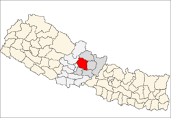
Kaski district
| Kaski कास्की |
|
|---|---|
| District | |
 Location of Kaski |
|
| Country | Nepal |
| Region | Western (Pashchimanchal) |
| Zone | Gandaki |
| Headquarters | Pokhara |
| Area | |
| • Total | 2,017 km2 (779 sq mi) |
| Population (2011) | |
| • Total | 492,098 |
| • Density | 240/km2 (630/sq mi) |
| Time zone | NPT (UTC+5:45) |
| Website | www.ddckaski.gov.np/ |
Kaski District (Nepali: ![]() Listen , a part of Province No. 4, is one of the seventy-five districts of Nepal. The name is disambiguated from Kaskikot, the ancient Kaski Kingdom.
Listen , a part of Province No. 4, is one of the seventy-five districts of Nepal. The name is disambiguated from Kaskikot, the ancient Kaski Kingdom.
The district, with Pokhara as its district headquarters, covers an area of 2,017 square km and had a population of 492,098 according to 2011 Census. This district lies at the centroid point of the country. The altitude of Kaski district ranges from 450 meters the lowest land to 8091 meters the highest point in the Himalaya range. Kaski District politically has 32 VDCs, 2 municipalities, 13 ilakas and 4 electoral sectors.
The district covers parts of the Annapurna mountain range, and the picturesque scene of the mountains can be observed from most parts of the district. It is one of the best tourist destinations of Nepal. The district is full of rivers such as SetiGandaki, Modi and Madi along with other rivulets. The district headquarters Pokhara lies about 750 m above the sea level and is one of the best tourist destinations in the world. The district is famous for the Himalayan range with about 11 Himalayas with height greater than 7000 m. The famous Peaks include Machhapuchhre (Virgin Peak - 6993m). The Annapurna Range in the northern side is always full of snow. The beautiful scenery of northern mountains, gorge of Seti River, Davis Falls, natural caves, Fewa Lake, Begnas Lake and Rupa Lake are important natural resources of this district with great tourism values.
...
Wikipedia
