Kappel am Albis
| Kappel am Albis | ||
|---|---|---|
 |
||
|
||
| Coordinates: 47°14′N 8°31′E / 47.233°N 8.517°ECoordinates: 47°14′N 8°31′E / 47.233°N 8.517°E | ||
| Country | Switzerland | |
| Canton | Zurich | |
| District | Affoltern-am-Albis | |
| Government | ||
| • Mayor | Kurt Bär | |
| Area | ||
| • Total | 7.91 km2 (3.05 sq mi) | |
| Elevation | 573 m (1,880 ft) | |
| Population (Dec 2015) | ||
| • Total | 1,029 | |
| • Density | 130/km2 (340/sq mi) | |
| Postal code | 8926 | |
| SFOS number | 0006 | |
| Surrounded by | Baar (ZG), Hausen am Albis, Knonau, Mettmenstetten, Rifferswil, Steinhausen (ZG) | |
| Website |
www SFSO statistics |
|
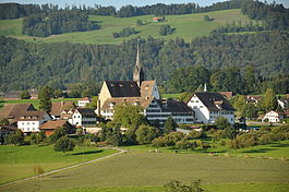
Kappel am Albis is a municipality in the district of Affoltern in the canton of Zürich in Switzerland.
Its name of Kappel (German: chapel) is specified by "on the Albis" to distinguish it from two other villages called Kappel in Switzerland.
Kappel am Albis is first mentioned in 1185 as de Capella.
The settlement was founded in 1185 as a Cistercian monastery which today houses a seminar centre and Der Alte Post (The Old Post Office) which is a restaurant.
It was the location of the Wars of Kappel in 1529 and 1531, during the turmoils that accompanied the Reformation of Huldrych Zwingli. A monument to Zwingli is located nearby at the hamlet of Näfenhäuser and can be seen to the right of the road on the Kappel am Albis website picture at Näfenhäuser with Zwingli monument.
Kappel am Albis has an area of 7.8 km2 (3.0 sq mi). Of this area, 70.6% is used for agricultural purposes, while 21% is forested. Of the rest of the land, 7.4% is settled (buildings or roads) and the remainder (1%) is non-productive (rivers, glaciers or mountains).
Kappel am Albis has a population (as of 31 December 2015) of 1,029. As of 2007[update], 8.9% of the population was made up of foreign nationals. Over the last 10 years the population has decreased at a rate of -0.7%. Most of the population (as of 2000[update]) speaks German (96.1%), with English being second most common ( 1.3%) and French being third ( 0.7%).
...
Wikipedia


