Kapatagan, Lanao del Sur
| Kapatagan | |
|---|---|
| Municipality | |
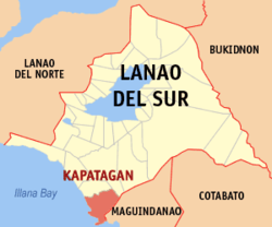
 Map of Lanao del Sur with Kapatagan highlighted |
|
| Location within the Philippines | |
| Coordinates: 07°27′N 124°08′E / 7.450°N 124.133°ECoordinates: 07°27′N 124°08′E / 7.450°N 124.133°E | |
| Country | Philippines |
| Region | Autonomous Region in Muslim Mindanao (ARMM) |
| Province | Lanao del Sur |
| Barangays | 15 |
| Government | |
| • Mayor | Nhazruddin Maglangit |
| Area | |
| • Total | 288.13 km2 (111.25 sq mi) |
| Population (2015 census) | |
| • Total | 15,521 |
| • Density | 54/km2 (140/sq mi) |
| Time zone | PST (UTC+8) |
| ZIP code | 9700 |
| IDD : area code | +63 (0)63 |
| Income class | 4th municipal income class |
| 153639000 | |
| Electorate | 9,098 voters as of 2016 |
| Website | www |
Kapatagan is a fourth class municipality in the province of Lanao del Sur, Philippines. According to the 2015 census, it has a population of 15,521 people.
Kapatagan is politically subdivided into 15 barangays.
...
Wikipedia

