Kandivali
|
Kandivali कांदिवली |
|
|---|---|
| suburb | |

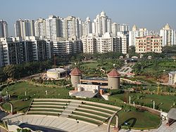
Thakur Village in Kandivali (East)
|
|
| Coordinates: 19°12′16″N 72°50′16″E / 19.204511°N 72.837639°ECoordinates: 19°12′16″N 72°50′16″E / 19.204511°N 72.837639°E | |
| Country | India |
| State | Maharashtra |
| District | Mumbai Suburban |
| Metro | Mumbai |
| Languages | |
| • Official | Marathi |
| Time zone | IST (UTC+5:30) |
| PIN | 400067, 400101 |
| Vehicle registration | MH-47(since May 2015) MH-02 (before May 2015) |
| Lok Sabha constituency | Mumbai North |
| Vidhan Sabha constituency |
Charkop Borivali (cover western parts of the suburb) Kandivali East Magathane (cover eastern parts of the suburb) |
Kandivali(formerly Khandolee) is a suburb in the northern part of Mumbai, Maharashtra, India. It is the 20th railway station from south to north within Mumbai.
Artifacts found near Kandivali indicate that the region was inhabited in the Stone Age.
The Kandivali railway station was built more than 100 years ago in 1907, then known as Khandolee.The station derived its name from the East Indian village of Condolim. Earth and stones from Paran, a hillock east of the Kandivali railway station were quarried to reclaim the Bombay Backbay. On this account a railway line was opened, a workshop erected and a number of dwelling houses were constructed for officers and workmen numbering hundreds. The area around Western Express Highway between Malad and Kandivali had numerous stone quarries and was once famous for Malad Stone. Many heritage buildings in Mumbai were constructed with Malad stone between 1860 and 1930, notable among them are David Sasson library, Bombay House and the Western Railway building at Churchgate.
During the plagues of 1900s, the Fonsecas from Bandra migrated to Kandivali, they initially settled down to the east of Kandivali at Akurli and then moved to the west at Poisar. This is where the East Indians thrived and a few families still reside to this day.
During the boom that followed the First World War(1914–18), several Gujaratis flocked near the newly opened railway station of Kandivali. On account of its healthy climate, good water and rural life, the Gujaratis built homes towards the west of the railway station. They soon outnumbered the people in the village. A few Parsis also bought large pieces of land near the village. A municipal body on a smaller scale known as the Notified Area Committee including the villages of Kandivali and Poisar was soon established. A Town Planning Scheme, launched by the Government to attract more people to the place did not materialize due to the depression of the 1930s. The township was semi-rural up to the 1980s, with agricultural land, huts and villages. With the real estate boom in the 1980s and 1990s, many residential projects started to shift northward.
...
Wikipedia

