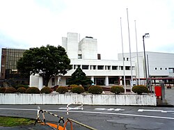
Kaminoyama, Yamagata
|
Kaminoyama 上山市 |
|||
|---|---|---|---|
| City | |||

Kaminoyama City Hall
|
|||
|
|||
 Location of Kaminoyama in Yamagata Prefecture |
|||
| Coordinates: 38°8′58.5″N 140°16′4.3″E / 38.149583°N 140.267861°ECoordinates: 38°8′58.5″N 140°16′4.3″E / 38.149583°N 140.267861°E | |||
| Country | Japan | ||
| Region | Tōhoku | ||
| Prefecture | Yamagata | ||
| Area | |||
| • Total | 240.93 km2 (93.02 sq mi) | ||
| Population (November 2015) | |||
| • Total | 31,476 | ||
| • Density | 131/km2 (340/sq mi) | ||
| Time zone | Japan Standard Time (UTC+9) | ||
| City symbols | |||
| - Tree | Japanese yew | ||
| - Flower | Chrysanthemum | ||
| - Bird | Little egret | ||
| Phone number | 023-672-1111 | ||
| Address | 1-1-10 Kawasaki, Kaminoyama-shi, Yamagata-ken 999-3192 | ||
| Website | Official website | ||
Kaminoyama (上山市 Kaminoyama-shi?) is a city located in Yamagata Prefecture, in the northern Tohoku region of Japan.
As of October 2015, the city had an estimated population of 31,476 and a population density of 131 persons per km2. The total area was 240.93 square kilometres (93 sq mi).
Kaminoyama is located in southeast Yamagata Prefecture, in the Murayama Basin, bordered by Miyagi Prefecture to the east. Mount Zaō is located within its borders.
Kaminoyama has a Humid continental climate (Köppen climate classification Dfa) with large seasonal temperature differences, with warm to hot (and often humid) summers and cold (sometimes severely cold) winters. Precipitation is significant throughout the year, but is heaviest from August to October.
The area of present-day Kaminoyama was part of ancient Dewa Province, and was a castle town for Kaminoyama Domain under the Tokugawa shogunate in the Edo period. It was also a post station on the Ushū Kaidō highway. After the start of the Meiji period, the area became part of Minamimurayama District, Yamagata Prefecture. The modern town of Kaminoyama was established on April 1, 1889, and was elevated to city status on October 1, 1954.
...
Wikipedia


