Kamembe Airport
| Kamembe International Airport | |||||||||||
|---|---|---|---|---|---|---|---|---|---|---|---|

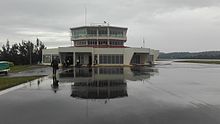
Kamembe airport terminal seen from the runway, 2017
|
|||||||||||
| Summary | |||||||||||
| Airport type | Civil | ||||||||||
| Owner | Rwandan Government | ||||||||||
| Operator | Rwanda Airports Authority | ||||||||||
| Serves | Cyangugu | ||||||||||
| Location | Kamembe, Rwanda | ||||||||||
| Elevation AMSL | 1,491 m / 4,891 ft | ||||||||||
| Coordinates | 02°27′44″S 028°54′28″E / 2.46222°S 28.90778°ECoordinates: 02°27′44″S 028°54′28″E / 2.46222°S 28.90778°E | ||||||||||
| Map | |||||||||||
| Location of the airport in Rwanda | |||||||||||
| Runways | |||||||||||
|
|||||||||||
|
Source: DAFIF
|
|||||||||||
Kamembe International Airport is an airport for Cyangugu and Kamembe in Rwanda (IATA: KME, ICAO: HRZA). RwandAir had operated a Dash 8-Q400 with nine flights per week to and from Kigali, but has currently suspended service until runway resurfacing is completed. The airport receives charter flights from Tanzania, Uganda and Democratic Republic of the Congo, though not on a regular schedule.
During the Rwandan Civil War, Kamembe airport was suggested as a site for transiting French arms to the interim government after April 1994.
The airport terminal building was heavily damaged by a 2008 earthquake, and early in 2010 the Rwanda government announced that Kamembe Airport would be modernized. By the end of 2012 a new terminal was completed, a new control tower was opened, and Techno Sky, a branch of the Italian publicly owned ENAV corporation, had installed new navigation systems.
During a May 2013 visit, Infrastructure Minister Albert Nsengiyumva announced that the runway would be widened and lengthened from 1.5 kilometres to 2.2 kilometres by 2014-2015. The airport re-opened in June 2015 and RwandAir began scheduled flights from the airport.
...
Wikipedia

