Kajiwa Dam
| Kajiwa Dam | |
|---|---|
|
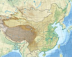
Location of Kajiwa Dam in China
|
|
| Country | China |
| Location | Kajiwa, Muli Tibetan Autonomous County, Sichuan Province |
| Coordinates | 28°42′47.50″N 100°53′15.68″E / 28.7131944°N 100.8876889°ECoordinates: 28°42′47.50″N 100°53′15.68″E / 28.7131944°N 100.8876889°E |
| Purpose | Power |
| Status | Operational |
| Construction began | 2008 |
| Opening date | 2014 |
| Dam and spillways | |
| Type of dam | Embankment, concrete-face rock-fill |
| Impounds | Muli River |
| Height | 171 m (561 ft) |
| Length | 323 m (1,060 ft) |
| Reservoir | |
| Total capacity | 375,000,000 m3 (304,000 acre·ft) |
| Power station | |
| Name | Kajiwa Hydropower Plant |
| Coordinates | 28°39′39.96″N 100°55′12.88″E / 28.6611000°N 100.9202444°E |
| Commission date | 2015 |
| Type | Conventional, diversion |
| Turbines | 4 x 110 MW, 2 x 6.2 MW Francis-type |
| Installed capacity | 452.4 MW |
The Kajiwa Dam is a concrete-face rock-fill dam on the Muli River near Kajiwa in Muli Tibetan Autonomous County, Sichuan Province, China. Preliminary construction (roads, bridges, foundation work) on the dam began in 2008 and construction on the 452.4 MW power station began in August 2011. The dam began to impound its reservoir in December 2014. The first 110 MW unit was commissioned on 16 March 2015. The power station was expected to be fully operational by the end of 2015. To operate, water from the dam is sent to a power station about 6 km (3.7 mi) downstream.
...
Wikipedia

