Kafr Qara
Kafr Qara
|
||
|---|---|---|
| Hebrew transcription(s) | ||
| • ISO 259 | Kpar Qáriˁ | |
| • Also spelled | Kefar Qara (official) Kfar Qari (unofficial) |
|
 |
||
|
||
| Coordinates: 32°30′20.89″N 35°3′13.76″E / 32.5058028°N 35.0538222°ECoordinates: 32°30′20.89″N 35°3′13.76″E / 32.5058028°N 35.0538222°E | ||
| District | Haifa | |
| Government | ||
| • Type | Local council | |
| Area | ||
| • Total | 7,000 dunams (7 km2 or 3 sq mi) | |
| Population (2015) | ||
| • Total | 17,689 | |
| Name meaning | "The village of the gourd" | |
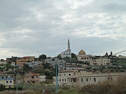
Kafr Qara (Arabic: كفر قرع, Hebrew: כַּפְר קַרִע; also spelled Kafr Qari) is an Arab town in Israel 22 miles (35 km) southeast of Haifa. In 2015 its population was 17,689. Kafr Qara holds the highest record for doctors relative to population size in the country, around 14.8 doctors per 1,000 citizens (2007, with more than 50 medicine student back then), Kafr Qara known as well for recording a high rate of academics and master's degree holders.[2].
In 1859 the population was 450 people, who cultivated 32 feddans of land. In 1883, the Palestine Exploration Fund's Survey of Western Palestine described Kefr Kara as a "good-sized stone village on high ground, with a well to the east, and caves."
In the 1922 census of Palestine conducted by the British Mandate authorities, Kufr Qara had a population 776, 9 Christians and 767 Muslims. This had increased in the 1931 census to 1,109, 4 Christians and 1,105 Muslims, in 198 houses.
In 1945, Kafr Qara had a population of 1,510 Arabs, who owned 14,543 dunams of land. Of this, 227 dunams were for plantations and irrigable land, 11,516 for cereals, while 25 dunams were built-up (urban) land.
Kafr Qara is part of the Triangle. It is located in the Wadi Ara region, northwest of the Green Line. Most of the inhabitants are Muslim. It is governed by a local council. Kafr Qara now has about 7000 dunams of land left, after land was expropriated by the local authorities and Israeli government for public and military use. WAC, an independent labor association, is located in the village.
...
Wikipedia


