Kōriyama, Fukushima
|
Kōriyama 郡山市 |
|||
|---|---|---|---|
| Core city | |||

View of central Koriyama, from Tomihisayama Hill
|
|||
|
|||
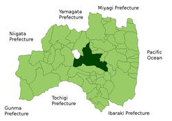
 Location of Kōriyama in Fukushima Prefecture |
|||
| Coordinates: 37°24′16″N 140°21′35″E / 37.40444°N 140.35972°ECoordinates: 37°24′16″N 140°21′35″E / 37.40444°N 140.35972°E | |||
| Country | Japan | ||
| Region | Tōhoku | ||
| Prefecture | Fukushima Prefecture | ||
| Government | |||
| • - Mayor | Masato Shinagawa | ||
| Area | |||
| • Total | 757.06 km2 (292.30 sq mi) | ||
| Population (February 2015) | |||
| • Total | 329,339 | ||
| • Density | 435/km2 (1,130/sq mi) | ||
| Time zone | Japan Standard Time (UTC+9) | ||
| - Tree | Prunus serrulata (Japanese hill cherry) | ||
| - Flower | Japanese iris | ||
| - Bird | Common cuckoo | ||
| Phone number | 024-924-2491 | ||
| Address | 1-23-7 Asahi, Koriyama, Fukushima 963-8024 | ||
| Website | www |
||
| Kōriyama, Fukushima | ||||||||||||||||||||||||||||||||||||||||||||||||||||||||||||
|---|---|---|---|---|---|---|---|---|---|---|---|---|---|---|---|---|---|---|---|---|---|---|---|---|---|---|---|---|---|---|---|---|---|---|---|---|---|---|---|---|---|---|---|---|---|---|---|---|---|---|---|---|---|---|---|---|---|---|---|---|
| Climate chart () | ||||||||||||||||||||||||||||||||||||||||||||||||||||||||||||
|
||||||||||||||||||||||||||||||||||||||||||||||||||||||||||||
|
||||||||||||||||||||||||||||||||||||||||||||||||||||||||||||
| J | F | M | A | M | J | J | A | S | O | N | D |
|
37
4
−3
|
38
5
−2
|
70
9
0
|
83
16
5
|
100
21
11
|
127
24
15
|
185
28
19
|
152
29
21
|
165
25
16
|
111
19
10
|
63
13
4
|
33
8
0
|
| Average max. and min. temperatures in °C | |||||||||||
| Precipitation totals in mm | |||||||||||
| Source: Japan Meteorological Agency | |||||||||||
| Imperial conversion | |||||||||||
|---|---|---|---|---|---|---|---|---|---|---|---|
| J | F | M | A | M | J | J | A | S | O | N | D |
|
1.5
40
27
|
1.5
41
28
|
2.8
48
32
|
3.3
61
41
|
3.9
70
51
|
5
76
60
|
7.3
82
67
|
...
| ||||


