Külf
| Külf | |
|---|---|
| Highest point | |
| Peak | unnamed summit |
| Elevation | 260 m (850 ft) |
| Dimensions | |
| Length | 9 km (5.6 mi) |
| Geography | |
| Country | Germany |
| State | Lower Saxony |
| Range coordinates | 52°02′N 9°45′E / 52.03°N 9.75°ECoordinates: 52°02′N 9°45′E / 52.03°N 9.75°E |
| Parent range | Leine Uplands |
| Geology | |
| Age of rock | Lower muschelkalk, Bunter Sandstone |
| Type of rock | limestone, marl, sandstone |
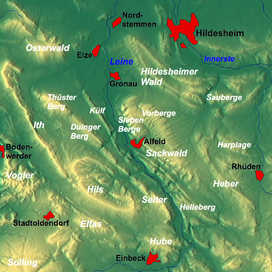
The Külf is a ridge, up to 260 m above NN, in the Leine Uplands in the district of Hildesheim in the German state of Lower Saxony.
With seven main summits, the Külf stretches for about 9 kilometres, lying in a triangle formed by the settlements of Gronau, Alfeld and Duingen. It is located between Eime and Banteln to the north, Dehnsen to the east, Limmer to the southeast, Brunkensen to the south and Hoyershausen, Lübbrechtsen and Deinsen to the west. West of the Külf is another ridge, the Thüster Berg, to the southwest is the Duinger Berg and to the east are the seven hills of the Sieben Berge. The B 3 federal road runs through the Leine valley from Gronau to Alfeld east of the Külf.
Geologically the Külf is part of the Alfeld Saddle, to which the Rettberg and Hackeberg to the south also belong (and extending to the north from Freden). Its underlying rocks consist of limestones of the muschelkalk, hard Trochitenkalk (Upper muschelkalk) and Wellenkalk (Lower muschelkalk).
The name of this hill range is alluded to in almost all the settlements that border it, not least the road names Am Külf (in Dehnsen), Külftalstraße (in Hoyershausen) as well as the names of local shops, such as the Külf-Apotheke ("Külf Chemists") and Külf-Backerei ("Külf Bakery"), both in Eime.
...
Wikipedia

