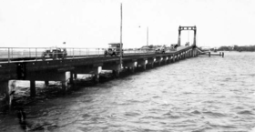
Jubilee Bridge, Southport
| Jubilee Bridge | |
|---|---|

Jubilee Bridge, Southport, circa 1932
|
|
| Coordinates | 27°58′28″S 153°25′22″E / 27.97451°S 153.42268°ECoordinates: 27°58′28″S 153°25′22″E / 27.97451°S 153.42268°E |
| Crosses | Nerang River |
| Locale | Gold Coast, Queensland |
| Owner | Gold Coast City Council |
| Followed by | Sundale Bridge |
| Characteristics | |
| Material | Deck: Ironbark and spotted gum |
| Trough construction | Piers: Reinforced concrete |
| Total length | circa 1,300 feet (400 m) |
| Width | 19 feet (5.8 m) |
| History | |
| Construction cost | ₤23,000 |
| Inaugurated | 28 November 1925 |
| Opened | 8 April 1925 |
| Closed | 1966 (and demolished) |
The Jubilee Bridge (1925–1966) was a bridge across the Nerang River in South East Queensland, Australia. The bridge connected the suburbs of Southport to Main Beach on the Gold Coast, providing the first road connection to Surfers Paradise. It facilitated the development of the Gold Coast beach suburbs and holiday resorts.
In 1887, German immigrant Johann Meyer operated a ferry across the Nerang River. From Southport, travellers would follow the Meyer's Ferry Road (now Ferry Road and Bundall Road) to a spit of land that created a narrow point in the river (28°00′04″S 153°25′29″E / 28.0011°S 153.4247°E). The narrow spit is no longer in existence due to changes in the river and the creation of Chevron Island but was in the vicinity of the Gold Coast Arts Centre. From that point, Meyer's ferry would take the travellers across the river to Meyer's Ferry Road at Elston (or the Main Surf Beach as it was then informally known, now Cavill Avenue, Surfers Paradise). Although a popular destination, the lack of road access limited the extent of residential and commercial development.
In 1925, the Southport Bridge (as it was initially known) was built as a direct extension of Queen Street, Southport in an approximate east-west alignment connecting to what is now Main Beach Parade, Main Beach (at that time Main Beach was not developed as it is today).
...
Wikipedia
