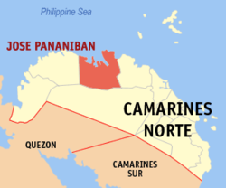
Jose Panganiban, Camarines Norte
|
Jose Panganiban (Mambulao) |
||
|---|---|---|
| Municipality | ||
| Municipality of Jose Panganiban | ||
 |
||
|
||
| Motto: Alay sa Diyos at sa Bayan | ||
 Location within Camarines Norte |
||
| Location within the Philippines | ||
| Coordinates: 14°18′N 122°42′E / 14.3°N 122.7°ECoordinates: 14°18′N 122°42′E / 14.3°N 122.7°E | ||
| Country |
|
|
| Region | Bicol Region-Region V | |
| Province | Camarines Norte | |
| District | 1st district | |
| Founded (as Mambulao) | 1571 | |
| Founded (as Jose Panganiban) | December 1, 1934 | |
| Barangays | 27 | |
| Government | ||
| • Type | Mayor–council government | |
| • Mayor | Ricarte Robledo Padilla (LP) | |
| • Vice Mayor | Ariel Mimay Non (LP) | |
| • Municipal Council |
Councilors
|
|
| Area | ||
| • Total | 214.44 km2 (82.80 sq mi) | |
| Elevation | 31 m (102 ft) | |
| Population (2015 census) | ||
| • Total | 59,639 | |
| • Density | 259/km2 (670/sq mi) | |
| Demonym(s) | Mambuleños | |
| Time zone | PST (UTC+8) | |
| ZIP code | 4606 | |
| IDD : area code | +63 (0)54 | |
| Income class | 2nd class | |
| Website | mambulao |
|
Jose Panganiban is a second-class municipality in the province of Camarines Norte, Philippines. According to the 2015 census, it has a population of 59,639 people.
The town of Jose Panganiban was formerly known as Mambulao, a word taken from “mambulawan,” meaning bountiful in gold. It was renamed to honor Jose Maria Panganiban on December 1, 1934.
Jose Panganiban is politically subdivided into 27 barangays.
In the 2015 census, the population of Jose Panganiban was 59,639 people, with a density of 280 inhabitants per square kilometre or 730 inhabitants per square mile.
It is known that even before the colonizers came, Mambulao was already a flourishing mining town. It was the Spaniards, drawn by the rumor of immense gold deposits in the Mambulao-Paracale district, who mastered in exploring the gold mining potentials of these towns.
From the 1750s to 1800s, Paracale held the major Spanish mines, but due to its closure in the 1790s, its people were living in desultory gold washing, fishing and selling betel nut to Mambulao which has now became the mining center. During that time, there were plenty of small shops but there’s no rice fields and vegetable gardening. All necessities came from Ambos Camarines and Tayabas (Quezon). Fifteen years later, the mines of Mambulao were no longer open. There was still some haphazard gold washing by women of Indio Class whose husbands, it was alleged, gambled away their meager earning in card games run by the town mayor. But by 1818, the population was back to the levels of the 1790s and by the mid-1820s annual gold production levels ran as 3,200 ounces (90.7 kg.) worth Php. 44,000 at prevailing prices. By 1829, Camarines Norte was considered to be wealthy and populous enough to warrant separation as province of its own for the first time. But after the 1840s the mining and population declined. Dr. Fedor Jagor (in his book Travels in the Philippines and The former Philippines thru Foreign Eyes), a well known German traveler who visited Mambulao in 1859, reported that it was thinly populated and that the mining mania was already ruined. From 1837 to 1876 the population of Mambulao and Paracale decreased by 30%.
...
Wikipedia


