John Day Fossil Beds
| John Day Fossil Beds National Monument | |
| U.S. National Monument | |
|
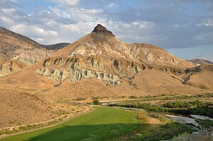
Sheep Rock near sunset
|
|
| Named for: the John Day River, which was named for early 19th-century fur trader John Day | |
| Country | United States |
|---|---|
| State | Oregon |
| Counties | Wheeler, Grant |
| Cities | Mitchell, Fossil, Dayville |
| Cant Ranch (park headquarters) |
Between Kimberly and Dayville |
| - elevation | 2,244 ft (684 m) |
| - coordinates | 44°33′21″N 119°38′43″W / 44.55583°N 119.64528°WCoordinates: 44°33′21″N 119°38′43″W / 44.55583°N 119.64528°W |
| Highest point | |
| - elevation | 4,500 ft (1,372 m) |
| Lowest point | |
| - elevation | 2,000 ft (610 m) |
| Total area | 14,062 acres (5,691 ha) |
| - Sheep Rock Unit | 8,843 acres (3,579 ha) |
| - Painted Hills Unit | 3,132 acres (1,267 ha) |
| - Clarno Unit | 1,969 acres (797 ha) |
| Geology | Eroded layers of volcanic ash |
| Established | October 8, 1975 |
| Management | National Park Service |
| Visitation | 210,000 in 2016 |
| IUCN category | III - Natural Monument |
| Website: John Day Fossil Beds National Monument | |
| Designated | 1966 |
John Day Fossil Beds National Monument is a U.S. National Monument in Wheeler and Grant counties in east-central Oregon. Located within the John Day River basin and managed by the National Park Service, the park is known for its well-preserved layers of fossil plants and mammals that lived in the region between the late Eocene, about 45 million years ago, and the late Miocene, about 5 million years ago. The monument consists of three geographically separate units: Sheep Rock, Painted Hills, and Clarno.
The units cover a total of 13,944 acres (5,643 ha) of semi-desert shrublands, riparian zones, and colorful badlands. About 210,000 people frequented the park in 2016 to engage in outdoor recreation or to visit the Thomas Condon Paleontology Center or the James Cant Ranch Historic District.
Before the arrival of Euro-Americans in the 19th century, the John Day basin was frequented by Sahaptin people who hunted, fished, and gathered roots and berries in the region. After road-building made the valley more accessible, settlers established farms, ranches, and a few small towns along the river and its tributaries. Paleontologists have been unearthing and studying the fossils in the region since 1864, when Thomas Condon, a missionary and amateur geologist, recognized their importance and made them known globally. Parts of the basin became a National Monument in 1975.
Averaging about 2,200 feet (670 m) in elevation, the monument has a dry climate with temperatures that vary from summer highs of about 90 °F (32 °C) to winter lows below freezing. The monument has more than 80 soil types that support a wide variety of flora, ranging from willow trees near the river to grasses on alluvial fans to cactus among rocks at higher elevations. Fauna include more than 50 species of resident and migratory birds. Large mammals like elk and smaller animals such as raccoons, coyotes, and voles frequent these units, which are also populated by a wide variety of reptiles, fish, butterflies, and other creatures adapted to particular niches of a mountainous semi-desert terrain.
...
Wikipedia


