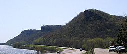
John A. Latsch State Park
| John A. Latsch State Park | |
| Minnesota State Park | |
|
Mounts Faith, Hope, and Charity in John A. Latsch State Park
|
|
| Country | |
|---|---|
| State | |
| County | Winona |
| Location | Minneiska |
| - elevation | 860 ft (262 m) |
| - coordinates | 44°9′43″N 91°49′20″W / 44.16194°N 91.82222°WCoordinates: 44°9′43″N 91°49′20″W / 44.16194°N 91.82222°W |
| Area | 1,654 acres (669.4 ha) |
| Founded | 1925 |
| Management | Minnesota Department of Natural Resources |
John A. Latsch State Park is a 1,654-acre (7 km2) state park of Minnesota, USA, on the Mississippi River, 12 miles (19 km) northwest of Winona. The park contains three steep bluffs rising 500 feet (150 m) above the river which are named Mount Faith, Mount Hope, and Mount Charity. The park is nearly undeveloped, with a small walk-in campground (closed to use currently) and only one trail. It functions primarily as a wayside on U.S. Route 61, which runs between the river and the base of the bluffs. Lock and Dam No. 5 is adjacent to the park.
The park sits on limestone laid down on the floor of a shallow sea 500 million years ago. Torrents of runoff at the end of the Wisconsin glaciation 10,000 years ago carved the bed of the Mississippi River down into this limestone, leaving high bluffs along its banks. The park is situated in the Driftless Area, an atypically rugged region of the Upper Midwest because it was never glaciated and covered with a layer of glacial till, or drift.
The steepness of the three bluffs deterred logging, and the forest cover today is a high quality mix of many different species. These include several kinds of oak, maple, elm, cedar, and ash, as well as black walnut, hickory, basswood, ironwood, birch, and poplar. A great variety of birds migrate past the park along the Mississippi Flyway. Terrestrial species include white-tailed deer, coyotes, foxes, opossums, and timber rattlesnakes.
The three bluffs were named by steamboat captains, who used them as landmarks. A logging town with its own steamboat landing was active here in the 1850s, supplying lumber to sawmills in newly founded Winona. The townsite has since been submerged by water backed up by the lock and dam.
...
Wikipedia


