Jew's House
| Jew's House, Lincoln | |
|---|---|

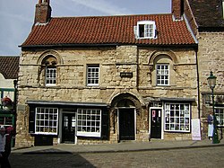
Frontage of the Jew's House, Lincoln
|
|
| Location | At the junction of Steep Hill and the Strait, between Uphill and Downhilll, Lincoln |
| Coordinates | 53°13′56″N 0°32′20″W / 53.2322°N 0.5388°WCoordinates: 53°13′56″N 0°32′20″W / 53.2322°N 0.5388°W |
| OS grid reference | SK9763371566 |
| Built | Later 12th Century |
| Architectural style(s) | Romanesque Town House |
|
Listed Building – Grade I
|
|
| Designated | 8 October 1953 |
| Reference no. | 486271 |
|
Location in Lincolnshire
|
|
The Jew's House is one of the earliest extant town houses in England. It is situated on Steep Hill in Lincoln, immediately below Jew's Court. The house has traditionally been associated with the thriving Jewish community in Medieval Lincoln. Anti-Semitic hysteria was stoked up by the case of Little Saint Hugh of Lincoln in 1255, and in 1290, the entire Jewish community was expelled from England; the Jew's House supposedly being seized from a Jewish owner. The building has remained continuously occupied to the present day. Since about 1973 it has been used as a restaurant and previous to that it was an Antiques shop.
The Jew’s House is built in the local limestone in the Norman or Romanesque style. Dating from the mid-twelfth century, the building originally consisted of a hall at first floor level, measuring approximately 12 by 6 metres, above service and storage spaces at ground level.
Part of the façade survives; the elaborately carved doorway, the remains of two Romanesque double-arch windows and much of the stonework on the upper storey. A chimney breast rises over the arch above the front door, serving the fireplace on the upper floor. There were once two columns supporting the arch, but these have gone.
...
Wikipedia

