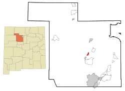
Jemez Pueblo, New Mexico
| Jemez Pueblo, New Mexico | |
|---|---|
| CDP | |
| Motto: The Gateway of the Jemez World | |
 Location of Jemez Pueblo, New Mexico |
|
| Location in the United States | |
| Coordinates: 35°36′38″N 106°43′39″W / 35.61056°N 106.72750°WCoordinates: 35°36′38″N 106°43′39″W / 35.61056°N 106.72750°W | |
| Country | United States |
| State | New Mexico |
| County | Sandoval |
| Area | |
| • Total | 2.0 sq mi (5.3 km2) |
| • Land | 2.0 sq mi (5.3 km2) |
| • Water | 0.0 sq mi (0.0 km2) |
| Elevation | 5,604 ft (1,708 m) |
| Population (2000) | |
| • Total | 1,953 |
| • Density | 957.0/sq mi (369.5/km2) |
| Time zone | Mountain (MST) (UTC-7) |
| • Summer (DST) | MDT (UTC-6) |
| ZIP code | 87024 |
| Area code(s) | 575 |
| FIPS code | 35-35250 |
| GNIS feature ID | 0928742 |
|
Jemez Pueblo
|
|

Jemez Pueblo, 1850 illustration
|
|
| Nearest city | Bernalillo, New Mexico |
| Area | 124 acres (50 ha) |
| Built | 1700 |
| Architectural style | Late Victorian, Pueblo |
| NRHP Reference # | 77000926 |
| NMSRCP # | 235 |
| Significant dates | |
| Added to NRHP | May 2, 1977 |
| Designated NMSRCP | February 1, 1972 |
Jemez Pueblo (HEH-mes; Towa: Walatowa) is a census-designated place (CDP) in Sandoval County, New Mexico, United States. The population was 1,953 at the 2000 census. It is part of the Albuquerque Metropolitan Statistical Area.
The CDP is named after the pueblo at its center. Among Pueblo members it is known as Walatowa.
Jemez Pueblo is located at 33°36′39″N 106°44′39″W / 33.61083°N 106.74417°W (35.610435, -106.727509).
According to the United States Census Bureau, the CDP has a total area of 5.3 km². There is no water on this piece of land.
It seems that a significant part of the Jemez Pueblo population originates from the surviving remnant of the Pecos Pueblo population who fled to Jemez Pueblo in 1838.
As of the census of 2000, there were 1,953 people, 467 households, and 415 families residing in the CDP. The population density was 957.0 people per square mile (369.6/km²). There were 499 housing units at an average density of 244.5 per square mile (94.4/km²). The racial makeup of the CDP was 0.41% White, 99.13% Native American, 0.31% from other races, and 0.15% from two or more races. Hispanic or Latino of any race were 1.95% of the population.
...
Wikipedia


