Jay Cooke State Park
| Jay Cooke State Park | |
| Minnesota State Park | |
|
The St. Louis River in Jay Cooke State Park
|
|
| Country | United States |
|---|---|
| State | Minnesota |
| County | Carlton |
| Location | Carlton |
| - elevation | 928 ft (283 m) |
| - coordinates | 46°38′59″N 92°19′51″W / 46.64972°N 92.33083°WCoordinates: 46°38′59″N 92°19′51″W / 46.64972°N 92.33083°W |
| Area | 8,125 acres (3,288 ha) |
| Founded | 1915 |
| Management | Minnesota Department of Natural Resources |
|
Jay Cooke State Park CCC/Rustic Style Historic District
|
|

The River Inn is the visitor center for the park and was built by the Civilian Conservation Corps
|
|
| Location | Carlton County, Minnesota, Off MN 210 east of Carlton |
|---|---|
| Nearest city | Carlton, Minnesota |
| Coordinates | 46°39′15″N 92°22′17″W / 46.65417°N 92.37139°W |
| MPS | Minnesota State Park CCC/WPA/Rustic Style MPS |
| NRHP Reference # | 89001665 |
| Added to NRHP | June 11, 1992 |
|
Jay Cooke State Park CCC/WPA/Rustic Style Picnic Grounds
|
|

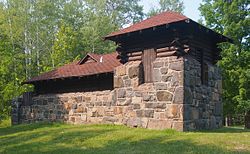
1934 water tower/latrine at Oldenburg Point
|
|
| Location | Off MN 210 SE of Forbay Lake, Thomson Township |
|---|---|
| Coordinates | 46°39′20″N 92°21′8″W / 46.65556°N 92.35222°W |
| MPS | Minnesota State Park CCC/WPA/Rustic Style MPS |
| NRHP Reference # | 92000640 |
| Added to NRHP | June 11, 1992 |
|
Jay Cooke State Park CCC/WPA/Rustic Style Service Yard
|
|
| Location | Off MN 210 E of Forbay Lake, Thomson Township |
|---|---|
| Coordinates | 46°39′40″N 92°20′50″W / 46.66111°N 92.34722°W |
| MPS | Minnesota State Park CCC/WPA/Rustic Style MPS |
| NRHP Reference # | 92000642 |
| Added to NRHP | June 11, 1992 |
Jay Cooke State Park is a state park of Minnesota, United States, protecting the lower reaches of the St. Louis River. The park is located about 10 miles (16 km) southwest of Duluth and is one of the ten most visited state parks in Minnesota. The western half of the park contains part of a rocky, 13-mile (21 km) gorge. This was a major barrier to Native Americans and early Europeans traveling by canoe, which they bypassed with the challenging Grand Portage of the St. Louis River. The river was a vital link connecting the Mississippi waterways to the west with the Great Lakes to the east.
Today Minnesota State Highway 210 runs through Jay Cooke State Park. The 9 miles (14 km) of the route between Carlton and Highway 23—which include the park—are designated the Rushing Rapids Parkway, a state scenic byway.
The park is named for Pennsylvania financier Jay Cooke, who had developed a nearby power plant, which is still in use. The Grand Portage trail and three districts of 1930s park structures are listed on the National Register of Historic Places.
The first 2,350 acres (9.5 km2) of land on which the park is situated were donated to the state by the Saint Louis Power Company in 1915. The park remained generally undeveloped until 1933, when a Civilian Conservation Corps (CCC) camp was established on the site. The CCC camp built a rustic swinging bridge over the St. Louis River just slightly downstream from some torrential rapids and waterfalls. This camp also built a picnic shelter. The camp was disbanded in 1935, but a second camp was set up in 1939. This camp rebuilt the swinging bridge and built the River Inn, which now houses the visitor center. This camp was disbanded in 1942, shortly before the federal government ended the CCC entirely. In 1945 the state began to add more land to the park, eventually giving it its current size of 8,818 acres (3,569 ha).
...
Wikipedia


