Jarvis Island
| Nickname: Bunker Island | |
|---|---|

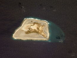
NASA satphoto of Jarvis Island; note the submerged reef beyond the eastern end.
|
|
| Etymology | Edward, Thomas and William Jarvis |
| Geography | |
| Location | South Pacific Ocean |
| Archipelago | Line Islands |
| Area | 4.5 km2 (1.7 sq mi) |
| Highest elevation | 7 m (23 ft) |
| Administration | |
|
USA
|
|

Jarvis Island Light in 2003
|
|
|
Pacific Ocean
|
|
| Location | Jarvis island Line Islands |
|---|---|
| Coordinates | 0°22′13.6″S 160°00′24.1″W / 0.370444°S 160.006694°W |
| Year first constructed | 1935 |
| Deactivated | 1942 |
| Construction | masonry tower |
| Tower shape | conical frustum tower, no lantern |
| Markings / pattern | white and red horizontal bands (originally) |
| Height | 5 metres (16 ft) |
| ARLHS number | PJI-001 |
Jarvis Island (/ˈdʒɑːrvᵻs/; formerly known as Bunker Island) is an uninhabited 1 3⁄4-square-mile (4.5 km2) coral island located in the South Pacific Ocean at 0°22′S 160°01′W / 0.367°S 160.017°WCoordinates: 0°22′S 160°01′W / 0.367°S 160.017°W, about halfway between Hawaii and the Cook Islands. It is an unincorporated, unorganized territory of the United States, administered by the United States Fish and Wildlife Service of the United States Department of the Interior as part of the National Wildlife Refuge system. Unlike most coral atolls, the lagoon on Jarvis is wholly dry.
...
Wikipedia

