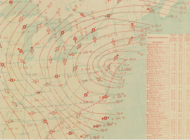
January 1886 Blizzard

Surface analysis of Blizzard on January 9, 1886.
|
|
| Type |
Extratropical cyclone Blizzard Winter storm |
|---|---|
| Formed | January 6, 1886 |
| Dissipated | January 11, 1886 |
| Maximum snowfall or ice accretion | 18.5 inches (47 cm) |
| Total fatalities | 38+ |
| Areas affected | Plains, South, and East |
The January 1886 blizzard was caused by a strong extratropical cyclone which initially dropped southeast across Texas before strengthening while it moved through the South and East, near the Eastern Seaboard through New England. The cyclone was at its strongest as it moved by New Jersey. This system formed within an active pattern which brought significant snow to the southern Rockies over many days. The system brought high winds and snowfall near and west of its path, resulting in blizzard conditions across portions of the Plains and East. A significant cold spell was ushered in by this system across portions of the southern and eastern United States. A slightly stronger storm on January 3, 1913 would break January low sea level pressure records originally set by this storm.
A cold wave was ongoing across the northern Plains when this low developed, with temperatures close to −50 °F (−46 °C) near the central Canada–US border. A surface low developed north of Texas on January 6, dropping southeast to the lower Texas coast early on January 7. The cyclone tracked inland of the coast through the Deep South later on January 7 and early January 8, before turning northeast through Georgia and emerging offshore the Virginia Capes late on January 8. The system reached its maximum intensity as it moved near New Jersey late on January 8.
The lowest pressure measured on land was 28.69 inches of mercury (972 hPa) at Philadelphia, Pennsylvania, Providence, Rhode Island, and Blue Hill Observatory in Massachusetts; the cyclone was considered one of the most extreme to pass through New England at the time. The storm's center then moved inland across Long Island by 11 a.m. on January 9, then across Rhode Island by 1 p.m. and Boston by 2 p.m. before turning northward through Maine around 10 p.m. Temperature readings quickly fell 10-15F (6-9 C) after the passage of the cyclone. High-level cirrus clouds led the center of circulation by 24 hours, with snow occurring 12 hours after the cirrus invasion. While weakening, the storm moved through southeast Quebec on January 10. The low pressure area moved at an average forward motion of 34 miles per hour (55 km/h) through the United States.
Fort Macon, North Carolina registered winds up to 62 miles per hour (100 km/h) from the southwest on January 8. The high winds led to the wreck of the Cressie Wright, with six of the seven aboard perishing. Norfolk, Virginia reported high winds which caused damage. High water and wave action from the Atlantic greatly damaged the New Jersey Southern Railroad track in Sandy Hook, New Jersey on January 9. The gale in New York City blew away the anemometer cups at the local weather observing site, and led to numerous maritime mishaps. A blizzard was caused by the high winds and heavy snow at New London, Connecticut. A schooner sank with all aboard offshore Charles Island.
...
Wikipedia
