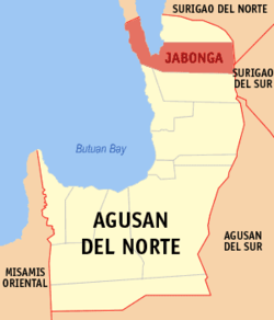
Jabonga, Agusan del Norte
| Jabonga | ||
|---|---|---|
| Municipality | ||

Brgy. Poblacion in Jabonga
|
||
|
||
 Location within Agusan del Norte province |
||
| Location within the Philippines | ||
| Coordinates: 9°20′N 125°31′E / 9.34°N 125.52°ECoordinates: 9°20′N 125°31′E / 9.34°N 125.52°E | ||
| Country | Philippines | |
| Region | Caraga (Region XIII) | |
| Province | Agusan del Norte | |
| District | 2nd district of Agusan del Norte | |
| Barangays | 15 (see Barangays) | |
| Government | ||
| • Type | Sangguniang Bayan | |
| • Mayor | Jasmin Flores Monton | |
| Area | ||
| • Total | 293 km2 (113 sq mi) | |
| Population (2015 census) | ||
| • Total | 23,184 | |
| • Density | 79/km2 (200/sq mi) | |
| • Voter (2016) | 14,928 | |
| Time zone | PST (UTC+8) | |
| ZIP code | 8607 | |
| IDD : area code | +63 (0)85 | |
| Income class | 3rd municipal income class | |
| 160205000 | ||
| Electorate | 14,928 voters as of 2016 | |
| Website | www |
|
Jabonga, officially the Municipality of Jabonga (Filipino: Bayan ng Jabonga), is a municipality in the province of Agusan del Norte in the Caraga (Region XIII) of the Philippines. The population was 23,184 at the 2015 census. In the 2016 electoral roll, it had 14,928 registered voters.
Jabonga traces its origin to a village formerly occupied by Negritoes and a few Christian immigrants led by a Manobo Negrito meztizo Angelecio Montante, also called Agaras. The village became known as Celopan, a name derived from the bamboos growing along the bank of the river that were made into smoking pipes.
Sometime during the mid-nineteenth century, the increasing number of inhabitants who were joined by Christian immigrants from other places transferred to a new settlement in the present site of Colorado. By this time, The Spanish government was already sending missionaries to all parts of the island and the group that went up the Kalinawan River reached the settlement of Colorado, a name derived from the word Colorado meaning colored, because of the white spotted arms of Domingo Mondoy, the brave settler who dared to face the newcomers. Proceeding upstream, the missionaries reached Celopan and seeing a native inside a hut, the floor of which was just one meter above the water, they asked him what the place was called. Thinking that the Spaniards were referring to the hut, he answered Habongan. Thus, Celopan was renamed Habongan which later became Jabonga.
Jabonga is located at 9°20′N 125°31′E / 9.34°N 125.52°E.
According to the Philippine Statistics Authority, the municipality has a land area of 293 square kilometres (113 sq mi) constituting 10.73% of the 2,730.24-square-kilometre- (1,054.15 sq mi) total area of Agusan del Norte.
...
Wikipedia


