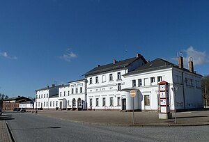
Jüterbog station
| Junction station | |

Entrance building, street side
|
|
| Location | Am Bahnhof 4, Jüterbog, Brandenburg Germany |
| Coordinates | 51°59′51″N 13°03′16″E / 51.99757°N 13.05442°ECoordinates: 51°59′51″N 13°03′16″E / 51.99757°N 13.05442°E |
| Line(s) |
|
| Platforms | 3 (formerly 7) |
| Other information | |
| Station code | 3071 |
| DS100 code | BJUE |
| IBNR | 8010182 |
| Category | 4 |
| Website | www.bahnhof.de |
| History | |
| Opened | 1 July 1841 |
Jüterbog station in a station in the town of Jüterbog in the German state of Brandenburg. It was opened in 1841, which makes it one of the oldest railway stations in Brandenburg. The Jüterbog–Röderau railway has branched off the Berlin–Halle railway (Anhalterbahn) at the station since 1848. Its importance grew with the opening of further railway lines. Some of these lines have now been closed.
The station has lost its former importance in the fields of long-distance passenger, freight and military transport. Today it is almost exclusively used for regional transport. The entrance building of the station is a protected monument. Also protected are the station building of the Royal Prussian Military Railway, which was used for public transport until the end of the First World War, further buildings of the military railway and the water tower of the former locomotive depot to the north-east of the station.
The station is located at line-kilometre 62.8 of the Berlin–Halle railway, calculated from the former Anhalter Bahnhof in Berlin. This line runs approximately north-east to south-west. The now disused route from Zossen, the former Military Railway, reached the station from the north-east, a little south of the direct line from Berlin. The 750 mm gauge railway from Dahme formerly ran to the station from the east. The line towards Falkenberg and Röderau branches southwards from the line to Halle. On the opposite side, the Jüterbog–Nauen railway branches off; this line soon turns towards the northwest.
The station is well outside the town center, about two kilometers west of the old town. It was originally developed in the open field near the Kappan estate, now the urban development has expanded to the station. The district of Jüterbog II, which was built on an old barracks ground is located on the north side of the station. At the southern end of the station, federal highway 102 crosses the rail tracks.
...
Wikipedia
