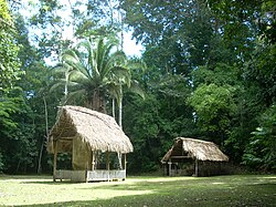
Ixkun

The North Plaza with Stelae 1 and 2
|
|
| Location | Dolores |
|---|---|
| Region |
Petén Department, |
| Coordinates | 16°34′25″N 89°24′40″W / 16.57361°N 89.41111°W |
| History | |
| Periods | Late Classic |
| Cultures | Maya civilization |
| Site notes | |
| Archaeologists |
Juan Pedro Laporte Atlas Arqueológico de Guatemala |
| Architecture | |
| Architectural styles | Classic Maya |
Juan Pedro Laporte
Ixkun (Ixcún or Ixkún in Spanish orthography) is a pre-Columbian Maya archaeological site, situated in the Petén Basin region of the southern Maya lowlands. It lies to the north of the town of Dolores, in the modern-day department of Petén, Guatemala. It is a large site containing many unrestored mounds and ruins and is the best known archaeological site within the municipality of Dolores.
Ixkun was the capital of one of the four largest kingdoms in the upper Mopan Valley, the others being Curucuitz, Ixcol and Ixtonton. Eight sites fell within the boundaries of the kingdom, showing a clear hierarchy. Stela 1 at Ixkun is one of the tallest stone monuments in the entire Petén Basin.
Although the main period of activity was during the Late Classic Period, the site was occupied from the Late Preclassic right through to the Postclassic Period.
Ixkun is located within the municipality of Dolores, 6.5 kilometres (4.0 mi) north of the town itself. The site is situated upon the Dolores plateau in the southern portion of the Petén Department of Guatemala, in the northwestern portion of the Maya Mountains. It occupies a series of karstic hills within a wide valley that covers 25 square kilometres (9.7 sq mi). The Mopan River flows 4 kilometres (2.5 mi) east of the ruins. The area covered by the kingdom included wide expanses suitable for agriculture, parts of the floodplains of the Mopan and Xa'an Rivers. The city was situated upon a north-south trade route that linked the Dolores Valley to the Mopan River, controlling access to Ucanal and other cities within the Mopan drainage.
...
Wikipedia

