Ithome
| Ithome, Ithomi | |
|---|---|
| Ἰθώμη | |

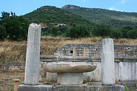
The twin peaks, Eva in the fore, Ithome in the back. The view is from the southeast side of Eva looking at the New Monastery in the foreground. Most of the ruins are on the other side.
|
|
| Highest point | |
| Elevation | 800 m (2,600 ft) |
| Prominence | 760 m (2,490 ft) |
| Coordinates | 37°11′10″N 21°55′30″E / 37.18611°N 21.92500°ECoordinates: 37°11′10″N 21°55′30″E / 37.18611°N 21.92500°E |
| Geography | |
|
Messenia, Greece
|
|
| Geology | |
| Mountain type | limestone karst |
| Climbing | |
| Easiest route | Zig-zag ancient dirt road on the southeast corner |
Mount Ithome (Greek: Ἰθώμη) or Ithomi, previously Vourkano(s) (Greek: Βουρκάνο(ς)) or Voulcano(s) (Greek: Βουλκάνο(ς)), is the northernmost of twin peaks in Messenia, Greece. Mount Ithome rises to about 800 metres (2,600 feet), about 760 metres (2,490 feet) over Valyra, the seat of Ithomi, the former municipality. The other peak is Mount Eva (Greek: Εύα), 700 metres (2,300 feet), connected to Mount Ithomi by a thin ridge 0.80 kilometres (0.50 miles) long.
Mount Ithome is 25 kilometres (16 miles) north of Kalamata on the Gulf of Messenia, 60 kilometres (37 miles) east of Pylos, seat of Bronze Age Messenia, and 20 kilometres (12 miles) north of Messini, modern namesake of ancient Messene, nestled under the cliffs of Mount Ithome. From the top the whole valley of the Pamisos river can be viewed eastward to Mount Taygetus and southward to the Gulf of Messenia. The site is highly defensible and yet off the main road; in this case, the Kalamata-Pylos road.
Like most ancient names the etymology of Ithome is not certain. It is also the name of a place in Thessaly, although Reece notes evidence that the one in Thessaly was originally called Thome.
The pre-independence name Vurcano has had many variants: Vourkano, Voulkanos, Vulcano, Voucano, Boulcano, Dorkano, Voulkani, etc. The name is not Greek. Its provenience, meaning and time of assignment are not known, like those of Morea. Ties to Vulcan or Volcano do not fit the geology. Ithome is not volcanic, evidences no volcanic deposits and its springs are not hot; in fact, they are known for their refreshing clarity and coolness.
One of the earliest records of a place called Bulcano is The Domains and Fiefs of the Principality of Achaia, composed for Marie of Bourbon, 1364. The Grand Seneschal of the Kingdom of Naples, Niccolo Acciajuoli, is said to possess Lo Castello de Bulcano (Messene) as a fief. The monastery on top, which dates to no later than the reign of the Byzantine emperor, Andronikos II Paleologus, 1282-1328, was probably known as Vurkano even then. The earliest major incursion of a non-Hellenic ethnic group is the settlement of the Slavic tribes of the Melingoi and Ezerites in the 7th and 8th centuries in Messenia and Sparta around Mount Taygetus as a defensible location. In the 9th and 10th centuries they ruled Messenia. At the time many classical names were changed to Slavic, only to be restored after independence. The Archaeological Museum of Messenia dates the name Vourkano to the 10th century. It, like Morea, is probably Slavic.
...
Wikipedia

