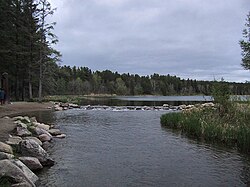
Itasca Lake
| Lake Itasca | |
|---|---|

The primary source of the Mississippi River on the edge of Lake Itasca
|
|
| Location | Itasca State Park, Clearwater County, Minnesota, US |
| Coordinates | 47°13′05″N 95°12′26″W / 47.21806°N 95.20722°WCoordinates: 47°13′05″N 95°12′26″W / 47.21806°N 95.20722°W |
| Type | Glacial |
| Primary inflows | Nicollet Creek, Elk Lake outlet stream |
| Primary outflows | Mississippi River |
| Basin countries | United States |
| Surface area | 1.8 sq mi (4.7 km2) |
| Average depth | 20–35 ft (6–11 m) |
| Surface elevation | 1,475 ft (450 m) |
| Islands | Schoolcraft Island |
Lake Itasca is a small glacial lake approximately 1.8 square miles (4.7 km2) in area. It is notable for being the headwaters of the Mississippi River, and is located in southeastern Clearwater County, in the Headwaters area of north central Minnesota. The lake is within Itasca State Park and has an average depth of 20 to 35 feet (6–11 m), and is 1,475 ft (450 m) above sea level.
The Ojibwe name for "Lake Itasca" is Omashkoozo-zaaga'igan (Elk Lake); this was changed by Henry Schoolcraft to "Itasca", coined from a combination of the Latin words veritas ("truth") and caput ("head"), though it is sometimes misinterpreted as "true head". It is one of several examples of pseudo-Indian place names created by Schoolcraft.
It is the primary source of the Mississippi River which flows 2,340 mi (3,770 km) to the Gulf of Mexico; There are several tributaries that flow (most or all of the year) into the lake, one of which, by most modern definitions, as with the Nile River and Amazon River, would be considered the actual source, though less dramatic than the lake's outflow. Henry Schoolcraft identified Lake Itasca as the river's primary source in 1832. He had been part of a previous expedition in 1820 led by General Lewis Cass that had named nearby Cass Lake (which is downstream from Itasca) as the source of the river.
The western arm of the lake is fed by two streams on its south end. Nicollet Creek starts in a nearby spring. Another small stream leads into Itasca from Elk Lake, which in turn is fed by two other streams. The Ojibwa called Elk Lake and the stream Bekegamaag-zaaga'igan and Bekegamaag-ziibi (Sidelake Lake and Sidelake River), respectively. In 1887 Williard Glazier promoted a campaign to consider Elk Lake, which he called Glazier Lake, as the true source of the Mississippi. Its longest tributary originates at Little Elk Lake, which is 100 ft (30 m) higher in elevation and 11 km upstream from the Lake Itasca outflow, at 47.158 N 95.224 W and in the Mississippi watershed.
...
Wikipedia
