Isole Eolie

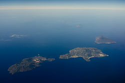
Aerial view of the Aeolian Islands
|
|

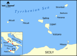
Map of the Aeolian Islands
|
|
| Geography | |
|---|---|
| Location | Tyrrhenian Sea |
| Coordinates | 38°32′N 14°54′E / 38.533°N 14.900°ECoordinates: 38°32′N 14°54′E / 38.533°N 14.900°E |
| Administration | |
|
Italy
|
|
| Region | Sicily |
| Province | Messina |
| UNESCO World Heritage Site | |
| Criteria | Natural: (viii) |
| Reference | 908 |
| Inscription | 2000 (24th Session) |
|
[]
|
|
The Aeolian Islands (/iːˈoʊliən/) (Italian: Isole Eolie, pronounced [ˈiːzole eˈɔːlje], Sicilian: Ìsuli Eoli, Greek: Αιολίδες Νήσοι, Aiolides Nisoi) are a volcanic archipelago in the Tyrrhenian Sea north of Sicily, named after the demigod of the winds Aeolus. The islands' inhabitants are known as Aeolians (Italian: Eoliani). The Aeolian Islands are a popular tourist destination in the summer and attract up to 200,000 visitors annually.
The largest island is Lipari and the islands are sometimes referred to as the Lipari Islands or Lipari group. The other islands include Vulcano, Salina, Stromboli, Filicudi, Alicudi, Panarea and Basiluzzo.
The present shape of the Aeolian Islands is the result of volcanic activity over a period of 260,000 years. There are two active volcanoes – Stromboli and Vulcano. The volcanic activity of steaming fumaroles and thermal waters are on most of the islands. The volcanic activity has also left the islands with very fertile soil that is conducive to the growth of natural flora.
...
Wikipedia
