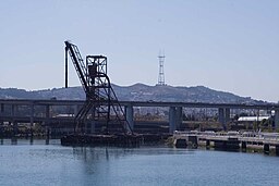
Islais Creek
| Islais Creek | |
| Creek | |
|
Islais Creek with an abandoned five-story-high copra crane,Interstate 280 and Sutro Tower in the background
|
|
| Name origin: Los Islais, Spanish and slay or islay, Salinan (Native American) for Prunus ilicifolia wild cherries | |
| Country | United States |
|---|---|
| State | California |
| Counties | City and County of San Francisco |
| City | San Francisco |
| Source | Cesar Chavez Street |
| - location | Near Potrero Hill, City and County of San Francisco, California |
| - elevation | 1 ft (0 m) |
| - coordinates | 37°44′51″N 122°23′16″W / 37.74750°N 122.38778°W |
| Mouth | San Francisco Bay |
| - location | Near Bayview-Hunters Point, City & County of San Francisco, California |
| - elevation | −10 ft (−3 m) |
| - coordinates | 37°44′54″N 122°22′32″W / 37.74833°N 122.37556°WCoordinates: 37°44′54″N 122°22′32″W / 37.74833°N 122.37556°W |
| Length | 1 mi (1.6 km) |
Islais Creek or Islais Creek Channel (previously known as Du Vrees Creek, Islais Channel and Islais Swamp) is a small creek in San Francisco, California. The name of the creek is derived from a Salinan Native American word "slay" or "islay", the name for the Prunus ilicifolia wild cherries. Around the time of the Gold Rush, the area became an industrial hub, and the condition of the creek worsened. After the devastating earthquake in 1906, the city decided to reclaim the creek using earthquake debris, reducing the waterbody to its present size. Though much of Islais Creek has been converted to an underground culvert, remnants still exist today at both Glen Canyon Park and Third Street. Several community organizations are dedicated to preserve these remnants, as they are important wildlife habitats.
The historic Islais Creek, the largest body of water in the city covering an area of nearly 5,000 acres (7.813 sq mi; 20.234 km2), had two main branches. One originated near the southern slope of Twin Peaks, slightly north of Portola Drive. It flowed downstream southeastward through the Glen Canyon Park paralleling Bosworth Street and eventually reaching the bottom of the Mission Street viaduct at I-280. The other branch began at the intersection of Cayuga Avenue and Regent Street. It flowed generally eastward along Mission Street and reached the I-280 viaduct. Together, as a wider creek, it ran parallel to Alemany Boulevard and I-280 and emptied into the Islais Creek estuary, near Industrial Street and Oakdale Avenue. Precita Creek, a nearby creek that originated from Noe Valley, also joined Islais Creek at the César Chávez Boulevard and Evans Avenue intersection.
...
Wikipedia

