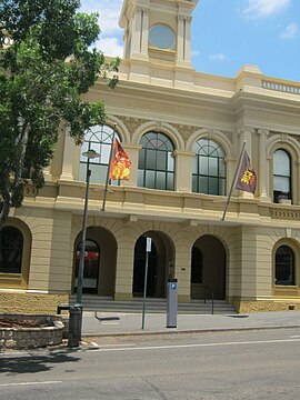
Ipswich CBD
|
Ipswich Ipswich, Queensland |
|||||||||||||
|---|---|---|---|---|---|---|---|---|---|---|---|---|---|

Ipswich Town Hall, 2012
|
|||||||||||||
| Population | 2,356 (2011) | ||||||||||||
| • Density | 561/km2 (1,453/sq mi) | ||||||||||||
| Established | 1843 | ||||||||||||
| Postcode(s) | 4305 | ||||||||||||
| Elevation | 40 m (131 ft) | ||||||||||||
| Area | 4.2 km2 (1.6 sq mi) | ||||||||||||
| Location | 39 km (24 mi) SW of Brisbane | ||||||||||||
| LGA(s) | City of Ipswich | ||||||||||||
| State electorate(s) | Ipswich | ||||||||||||
| Federal Division(s) | Blair, Oxley | ||||||||||||
|
|||||||||||||
Coordinates: 27°37′23″S 152°45′36″E / 27.623°S 152.760°E
Ipswich is the innermost suburb of Ipswich, Queensland, Australia. The suburb situated on the Bremer River. At the 2011 Australian Census the suburb recorded a population of 2,356.
The suburb of Ipswich has a number of distinct areas. The Ipswich central business district is in the north with the Bremer River forming the northern boundary. Limestone Hill and its parklands are to the east (27°37′01″S 152°46′09″E / 27.61694°S 152.76917°E). Denmark Hill with its exclusive residential area and conservation park is to the west (27°37′09″S 152°45′14″E / 27.61917°S 152.75389°E). A mixture of health, educations and residential areas make up the south.
...
Wikipedia
